|
|
| Mesoscale Discussion 657 | |
| < Previous MD | |

|
|
Mesoscale Discussion 0657
NWS Storm Prediction Center Norman OK
0453 PM CDT Mon May 06 2024
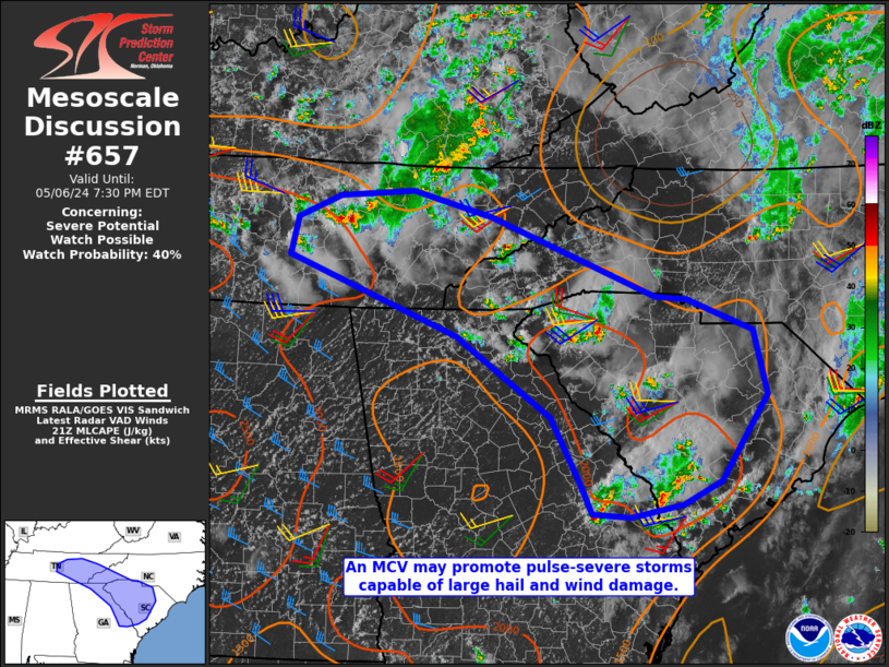
Areas affected...Portions of South Carolina and Tennessee Valley
Concerning...Severe potential...Watch possible
Valid 062153Z - 062330Z
Probability of Watch Issuance...40 percent
SUMMARY...Large hail and damaging winds are possible with modestly
organized, pulse-severe storms in parts of the Tennessee Valley into
South Carolina. Brief tornadoes are also possible for the next 1-2
hours in Middle/Eastern Tennessee with more discrete storms near the
MCV.
DISCUSSION...Large hail (with one 2 in. report) has occurred in
Middle Tennessee this afternoon. At least two TDS were also evident
on local radars. As this MCV continues east, strong to severe storms
are possible for the next 1-3 hours. Should cold pool organization
occur, some of this activity could reach parts of South Carolina
this evening.
Heating of a moist airmass along with some modest influence from an
MCV in the Tennessee Valley has promoted the development of widely
scattered storms across parts of South Carolina and nearby vicinity.
Deep layer shear is quite modest and outflow from storm has become
apparent on local radars. Some cold pool organization has occurred
in Upstate South Carolina which would locally enhanced the potential
for wind damage. Large hail has also been observed early in the
storm life cycle.
..Wendt/Guyer.. 05/06/2024
...Please see www.spc.noaa.gov for graphic product...
ATTN...WFO...RAH...ILM...CHS...CAE...GSP...MRX...FFC...OHX...
LAT...LON 33778284 34678414 35578643 35998634 36248576 36318474
36038365 35138141 35108099 34748007 34017990 33038053
32778105 32638176 32678228 33068247 33778284
|
|
|
Top/All Mesoscale Discussions/Forecast Products/Home |
|