|
|
| Mesoscale Discussion 650 | |
| < Previous MD | |

|
|
   Mesoscale Discussion 0650
   NWS Storm Prediction Center Norman OK
   1241 PM CDT Mon May 06 2024

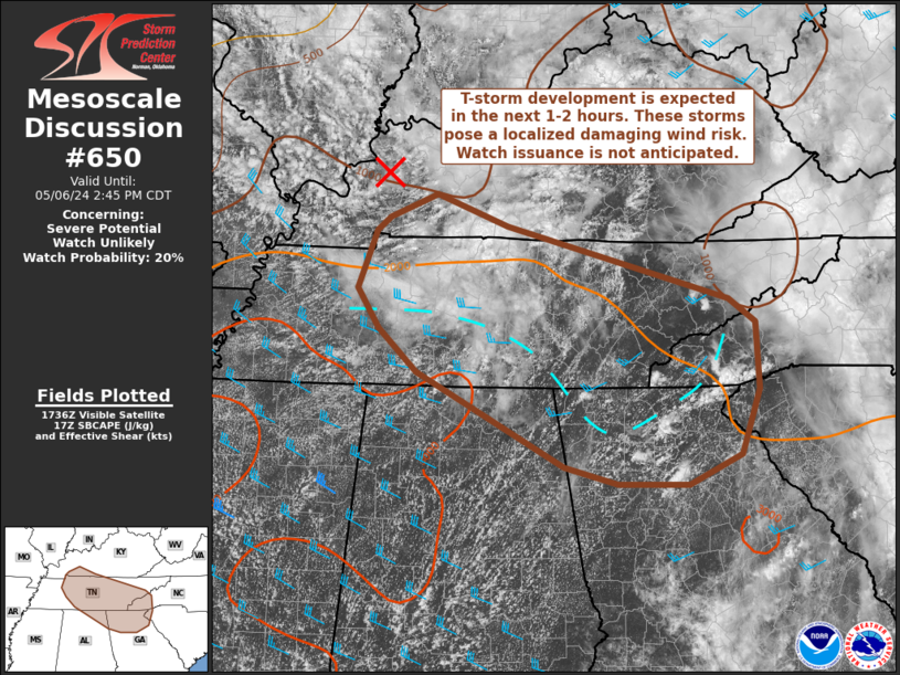
   Areas affected...Parts of the Tennessee River Valley/southern
   Appalachians

   Concerning...Severe potential...Watch unlikely

   Valid 061741Z - 061945Z

   Probability of Watch Issuance...20 percent

   SUMMARY...Thunderstorm development is expected along a residual
   outflow boundary and in the vicinity of an MCV across portions of
   the Tennessee River Valley. A couple of strong to severe storms are
   possible with an attendant risk of large hail and damaging gusts.

   DISCUSSION...17 UTC surface observations and visible imagery show
   gradual cumulus development and a few initial weak thunderstorms
   within a destabilizing air mass in the wake of early-morning
   convection. Higher theta-e air (characterized by temperatures in the
   upper 70s with dewpoints in the upper 60s/low 70s) is supporting
   MLCAPE values upwards of 1500 J/kg as it slowly spreads north ahead
   of a meandering MCV over the lower OH River Valley. Continued
   daytime heating through broken cloud cover should promote further
   destabilization and reduction of lingering MLCIN, making more robust
   convective initiation ahead of the MCV probable during the 18-20 UTC
   period. Despite weak low-level winds, enhanced 30-40 knot mid-level
   winds along the southern periphery of the MCV should sufficiently
   elongate hodographs to support storm organization, including the
   potential for a supercell or two. Consequently, large hail appears
   possible with the more robust/mature cells along with a low-end
   tornado threat given some veering of the low-level wind profile.
   Scattered thunderstorm development may promote upscale growth into
   clusters through late afternoon with an attendant increase in
   damaging wind potential. This threat is expected to remain somewhat
   confined close to the MCV as it migrates east, which should limit
   the overall coverage of the threat. Watch issuance appears unlikely
   at this time.

   ..Moore/Smith.. 05/06/2024

   ...Please see www.spc.noaa.gov for graphic product...

   ATTN...WFO...GSP...MRX...FFC...LMK...OHX...BMX...HUN...PAH...
   MEG...

   LAT...LON   34108545 35158744 35638796 36068825 36708800 36868783
               37128719 36778622 35968323 35708286 34958282 34248307
               33908379 33928474 34108545
|
|
|
Top/All Mesoscale Discussions/Forecast Products/Home |
|


