| Mesoscale Discussion 644 | |
| < Previous MD | |

|
|
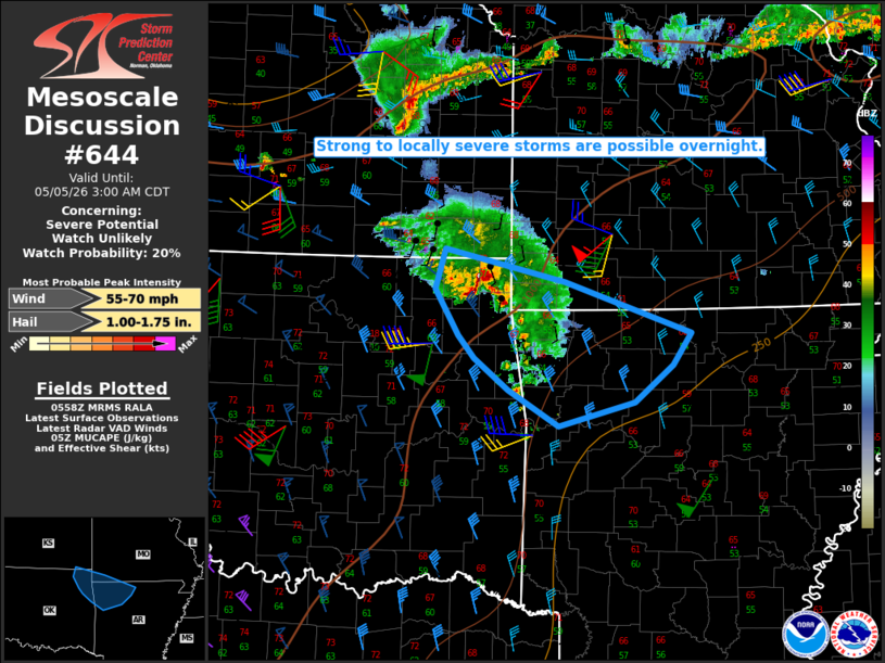
   Mesoscale Discussion 0644
   NWS Storm Prediction Center Norman OK
   0101 AM CDT Tue May 05 2026

   Areas affected...Northeast OK into northwest AR and far southwest MO

   Concerning...Severe potential...Watch unlikely

   Valid 050601Z - 050800Z

   Probability of Watch Issuance...20 percent

   SUMMARY...Strong to locally severe storms will remain possible
   overnight.

   DISCUSSION...An elevated storm cluster has recently shown some signs
   of organization across northeast OK, with convection increasing
   along both a developing cold pool and gust front, and within a warm
   advection regime near the OK/MO/AR border region. This cluster is
   being aided by a strong low-level jet, which should help to maintain
   this cluster as it moves southeastward overnight.

   Steep midlevel lapse rates (as observed on regional 00Z soundings),
   MUCAPE of near/above 1000 J/kg, and moderate effective shear will
   support some hail potential with the strongest embedded updrafts,
   though the ongoing cluster/linear mode may mitigate hail potential
   to some extent. Severe wind potential is also uncertain, due to the
   elevated nature of the ongoing convection. However, given the
   presence of a surface cold pool and sharp pressure rises (2-3
   mb/hour) behind the gust front noted on Mesonet observations in
   northeast OK, locally damaging wind could also accompany this system
   as it moves southeastward.

   ..Dean/Mosier.. 05/05/2026

   ...Please see www.spc.noaa.gov for graphic product...

   ATTN...WFO...LZK...SGF...TSA...ICT...

   LAT...LON   37099541 36769396 36279245 35969268 35609313 35379404
               35729464 36029506 36249525 36699553 37099541

   MOST PROBABLE PEAK WIND GUST...55-70 MPH
   MOST PROBABLE PEAK HAIL SIZE...1.00-1.75 IN
|
|
|
Top/All Mesoscale Discussions/Forecast Products/Home |
|
Source link