| Mesoscale Discussion 643 | |
| < Previous MD | |
|
|
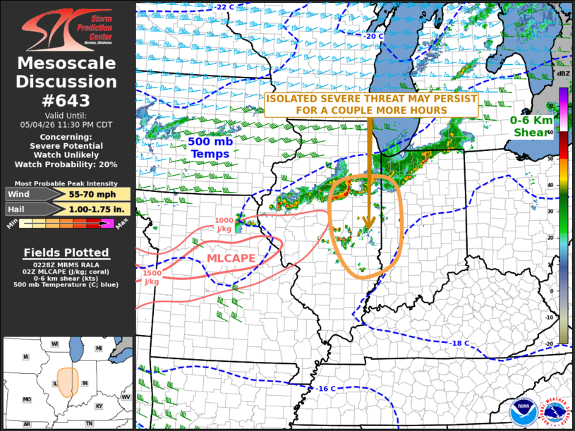
   Mesoscale Discussion 0643
   NWS Storm Prediction Center Norman OK
   0931 PM CDT Mon May 04 2026

   Areas affected...Eastern Illinois...Far Western Indiana

   Concerning...Severe potential...Watch unlikely

   Valid 050231Z - 050430Z

   Probability of Watch Issuance...20 percent

   SUMMARY...An isolated large hail threat may continue across eastern
   Illinois for a couple more hours, and could also affect far western
   Indiana. The severe threat area should remain relatively confined,
   and weather watch issuance is not expected.

   DISCUSSION...The latest RAP has an axis of moderate instability
   located from north-central Missouri east-northeastward into
   Illinois, where MLCAPE is in the 1000 to 1800 J/kg range. Convection
   has recently initiated along the far eastern edge of the stronger
   instability in central Illinois. The storms are being supported by
   low-level warm advection and may persist for a couple more hours.
   Steep mid-level lapse rates and moderate deep-layer shear, evident
   on regional WSR-88D VWPs, will likely support an isolated large hail
   threat. However, instability drops off quickly with eastward extent,
   suggesting that any severe threat should be relatively short-lived.

   ..Broyles/Hart.. 05/05/2026

   ...Please see www.spc.noaa.gov for graphic product...

   ATTN...WFO...IWX...IND...LOT...ILX...LSX...

   LAT...LON   39198698 38648798 38858862 39758912 40898904 41158774
               40788697 39198698

   MOST PROBABLE PEAK WIND GUST...55-70 MPH
   MOST PROBABLE PEAK HAIL SIZE...1.00-1.75 IN
|
|
|
Top/All Mesoscale Discussions/Forecast Products/Home |
|
Source link