| Mesoscale Discussion 63 | |
| < Previous MD Next MD > | |

|
|
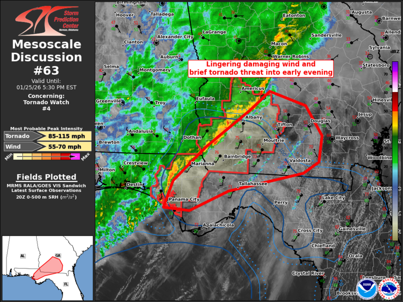
Mesoscale Discussion 0063 NWS Storm Prediction Center Norman OK 0255 PM CST Sun Jan 25 2026 Areas affected...central/eastern FL Panhandle and southern GA Concerning...Tornado Watch 4... Valid 252055Z - 252230Z The severe weather threat for Tornado Watch 4 continues. SUMMARY...Lingering damaging wind and brief tornado threat should linger into early evening as a QLCS mainly moves across southern Georgia. A downstream tornado watch issuance appears unlikely. DISCUSSION...After at least a few TDSs and measured wind gusts in the past couple hours, overall convective intensity may have peaked with the QLCS. It continues to move faster along the northern end, becoming elevated into central GA after progressing across the surface warm front. Mid 60s surface dew points, supportive of weak but adequate buoyancy for a brief tornado, have reached about 3 tiers of counties into southwest/south-central GA north of the FL border. Early afternoon guidance is insistent that convection should diminish in a couple hours as it overturns the remaining corridor of mid 70s surface temperatures across far southwest GA. The slower-moving portion of the line in the FL Panhandle should likewise wane after sunset, especially as low-level wind fields begin to subside ahead of the front at this latitude. ..Grams.. 01/25/2026 ...Please see www.spc.noaa.gov for graphic product... ATTN...WFO...JAX...FFC...TAE... LAT...LON 31768402 32088363 31828292 31318260 30858267 30668298 30378446 30028523 30088574 30538555 31128491 31768402 MOST PROBABLE PEAK TORNADO INTENSITY...85-115 MPH MOST PROBABLE PEAK WIND GUST...55-70 MPH |
|
|
Top/All Mesoscale Discussions/Forecast Products/Home |
|
Source link