| Mesoscale Discussion 625 | |
| < Previous MD | |

|
|
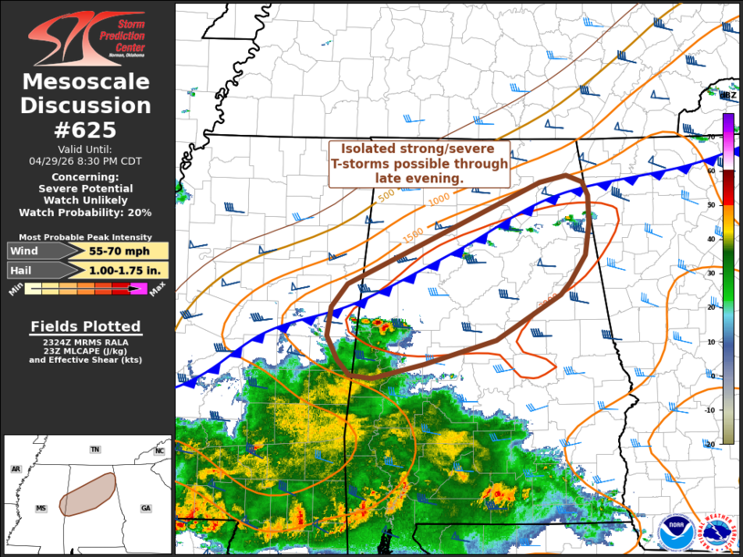
   Mesoscale Discussion 0625
   NWS Storm Prediction Center Norman OK
   0626 PM CDT Wed Apr 29 2026

   Areas affected...Far eastern Mississippi into central Alabama

   Concerning...Severe potential...Watch unlikely

   Valid 292326Z - 300130Z

   Probability of Watch Issuance...20 percent

   SUMMARY...A few strong to severe thunderstorms appear plausible
   across far eastern Mississippi into central Alabama as a front
   pushes south. Confidence in the coverage of thunderstorms is
   uncertain, and watch issuance is not expected at this time.

   DISCUSSION...Shallow convection has been percolating across central
   to northeast AL over the past hour, likely being driven by low-level
   ascent along a southward moving cold front. This front is migrating
   towards a fairly unstable air mass across central AL where
   temperatures remain in the upper 70s, MLCAPE has recently been
   analyzed near 2000 J/kg, and mid/upper-level flow is between 50-60
   knots (per regional VWPs).

   Given these trends, development along the front appears plausible in
   the coming hours and may pose some threat for severe hail and wind.
   Latest high-res guidance suggests the favorable convective
   environment across central AL will likely linger through 02 UTC,
   though the overall updraft/UH signal in these solutions appears
   modest (including output from the typically bullish RRFS), possibly
   due to somewhat weak low-level convergence along the front.
   Consequently, confidence in the severe threat is limited and watch
   issuance is not anticipated, but trends will be monitored.

   ..Moore/Hart.. 04/29/2026

   ...Please see www.spc.noaa.gov for graphic product...

   ATTN...WFO...FFC...BMX...HUN...JAN...

   LAT...LON   32498814 32538842 32698858 32938870 33238866 33478846
               34548607 34608574 34548554 34398547 34108545 33788551
               33508570 33378581 32898661 32658750 32498814

   MOST PROBABLE PEAK WIND GUST...55-70 MPH
   MOST PROBABLE PEAK HAIL SIZE...1.00-1.75 IN
|
|
|
Top/All Mesoscale Discussions/Forecast Products/Home |
|
Source link