| Mesoscale Discussion 617 | |
| < Previous MD Next MD > | |

|
|
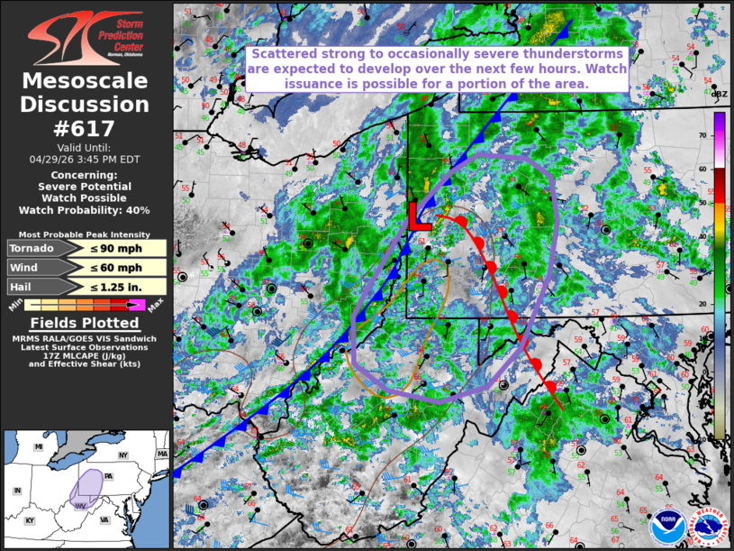
   Mesoscale Discussion 0617
   NWS Storm Prediction Center Norman OK
   1248 PM CDT Wed Apr 29 2026

   Areas affected...portions of the Upper Ohio River Valley

   Concerning...Severe potential...Watch possible

   Valid 291748Z - 291945Z

   Probability of Watch Issuance...40 percent

   SUMMARY...An increase in thunderstorm coverage is expected over the
   next couple of hours across the Upper Ohio River Valley, with
   stronger thunderstorms posing an isolated risk for strong wind gusts
   and a brief tornado or two.

   DISCUSSION...Latest surface analysis depicts a weak surface low
   along the Pennsylvania/Ohio border, with a trailing cold front
   extending southwestward into the mid-Ohio Valley. In the wake of
   morning precipitation, filtered diurnal heating ahead of this front
   coupled with dewpoints in the upper-50s F to near 60 are supporting
   weak buoyancy (around 500 J/kg MLCAPE per latest mesoanalysis).
   While the magnitude of additional destabilization remains uncertain,
   upper-level ascent ahead of an approaching shortwave trough coupled
   with favorable jet streak dynamics are expected to promote an
   increase in thunderstorm coverage along/ahead of the approaching
   cold front this afternoon. Effective bulk shear of 35-40 kts (per
   latest mesoanalysis) will be sufficient to support more organized
   convection, with potential for the development of a linear segment
   and/or low-topped supercells. Low-level hodograph curvature evident
   in the PBZ/RLX/CCX VAD profiles and 17z special sounding will likely
   support the potential for isolated strong wind gusts and a brief
   tornado or two with any stronger convection that can develop. Trends
   will continue to be monitored, and a small convective watch may be
   issued for a portion of the area.

   ..Chalmers/Smith.. 04/29/2026

   ...Please see www.spc.noaa.gov for graphic product...

   ATTN...WFO...CTP...LWX...PBZ...RLX...

   LAT...LON   39397888 38967935 38798004 38918077 39218125 39738127
               40008109 40838048 41347986 41537948 41487876 41287842
               40787832 40187846 39397888

   MOST PROBABLE PEAK TORNADO INTENSITY...UP TO 90 MPH
   MOST PROBABLE PEAK WIND GUST...UP TO 60 MPH
   MOST PROBABLE PEAK HAIL SIZE...UP TO 1.25 IN
|
|
|
Top/All Mesoscale Discussions/Forecast Products/Home |
|
Source link