| Mesoscale Discussion 608 | |
| < Previous MD Next MD > | |
|
|
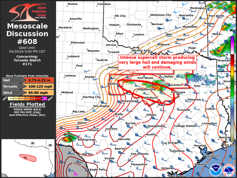
Mesoscale Discussion 0608 NWS Storm Prediction Center Norman OK 0702 PM CDT Tue Apr 28 2026 Areas affected...North Central TX Concerning...Tornado Watch 171... Valid 290002Z - 290200Z The severe weather threat for Tornado Watch 171 continues. SUMMARY...An intense supercell producing very large hail and damaging winds will continue southeastward. Other isolated cells may affect areas to west near Eastland and Stephenville. DISCUSSION...An intense supercell with a long history of very large and damaging hail is currently located in Johnson county TX. This cell will continue to track southeastward for the next 1-2 hours into a very moist and unstable air mass. Shear profiles are sufficient for all severe modes, including wind-driven significant hail and occasional tornadoes. New storms have formed on the western flank of the large supercell, over Stephens and Palo Pinto counties. These storms appear to be behind the primary outflow of the supercell, but sufficient elevated CAPE will pose a risk of large hail from this activity as it sags southeastward. ..Hart.. 04/29/2026 ...Please see www.spc.noaa.gov for graphic product... ATTN...WFO...FWD...SJT... LAT...LON 32629761 32319645 31949628 31779633 31679683 32219865 32529911 32709899 32629761 MOST PROBABLE PEAK TORNADO INTENSITY...100-125 MPH MOST PROBABLE PEAK WIND GUST...65-80 MPH MOST PROBABLE PEAK HAIL SIZE...2.75-4.25 IN |
|
|
Top/All Mesoscale Discussions/Forecast Products/Home |
|
Source link