| Mesoscale Discussion 604 | |
| < Previous MD | |

|
|
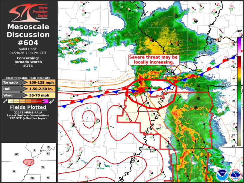
Mesoscale Discussion 0604 NWS Storm Prediction Center Norman OK 0526 PM CDT Tue Apr 28 2026 Areas affected...Extreme northeast Arkansas and the Missouri Bootheel Concerning...Tornado Watch 174... Valid 282226Z - 290000Z The severe weather threat for Tornado Watch 174 continues. SUMMARY...A supercell migrating across far southeast Missouri and northeast Arkansas may pose a locally higher severe threat over the next 1-2 hours. DISCUSSION...Surface observations across the MS Valley show a stationary boundary/outflow draped across northern AR into KY. A supercell with a history of producing severe hail and gusts up to 70 mph is approaching this boundary from the northwest along the eastern MO/AR border. Although MRMS 50 dBz echo tops depict a recent weakening trend with this storm, regional radar imagery has recently begun to sample strengthening mid-level flow within the storm (though precise feature identification is difficult given the storm's distance from the nearest RDA). Further intensification appears possible as the storm reaches the boundary where low-level SRH is enhanced and a more moist/buoyant air mass resides on the immediate warm side. This may support a localized corridor of higher severe hail, wind, and tornado potential within the next 1-2 hours. ..Moore.. 04/28/2026 ...Please see www.spc.noaa.gov for graphic product... ATTN...WFO...PAH...MEG... LAT...LON 36058967 36099003 36279055 36439072 36639071 36759053 36849028 36818940 36668909 36518911 36288919 36148941 36058967 MOST PROBABLE PEAK TORNADO INTENSITY...100-125 MPH MOST PROBABLE PEAK WIND GUST...55-70 MPH MOST PROBABLE PEAK HAIL SIZE...1.50-2.50 IN |
|
|
Top/All Mesoscale Discussions/Forecast Products/Home |
|
Source link