| Mesoscale Discussion 58 | |
| < Previous MD | |

|
|
Mesoscale Discussion 0058
NWS Storm Prediction Center Norman OK
1055 AM CST Sun Jan 25 2026
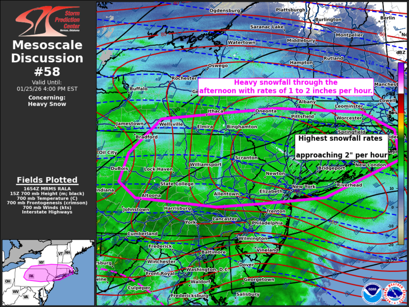
Areas affected...northern Pennsylvania...southern New
York...northern New Jersey...Connecticut...Rhode Island...and
southern Massachusetts.
Concerning...Heavy snow
Valid 251655Z - 252100Z
SUMMARY...Heavy snowfall is expected through the afternoon with
rates up to 2 inches per hour.
DISCUSSION...Widespread heavy snow is already ongoing across
Pennsylvania and New Jersey this morning. This heavy snow will shift
northeast through the afternoon. In addition, very heavy rates are
expected to develop across far southeast New York, Connecticut, and
Rhode Island. In this region, very strong 700mb frontogenesis is
forecast between 18Z and 21Z amid strong isentropic ascent.
In addition, amid strong warm-air advection, the transition zone
from snow to sleet is moving rapidly north across eastern
Pennsylvania and New Jersey (as sampled by KDOX Correlation
Coefficient). Expect this transition zone to continue to advect
north during the early afternoon before stalling near the
Connecticut shore by mid-afternoon.
..Bentley.. 01/25/2026
...Please see www.spc.noaa.gov for graphic product...
ATTN...WFO...BOX...OKX...ALY...PHI...BGM...BUF...CTP...PBZ...
LAT...LON 40547360 40457485 40387616 40537855 40897905 41537880
42327785 42587441 42457181 42037085 41367074 40587296
40547360
|
|
|
Top/All Mesoscale Discussions/Forecast Products/Home |
|
Source link