| Mesoscale Discussion 57 | |
| < Previous MD | |

|
|
   Mesoscale Discussion 0057
   NWS Storm Prediction Center Norman OK
   0955 AM CST Sun Jan 25 2026

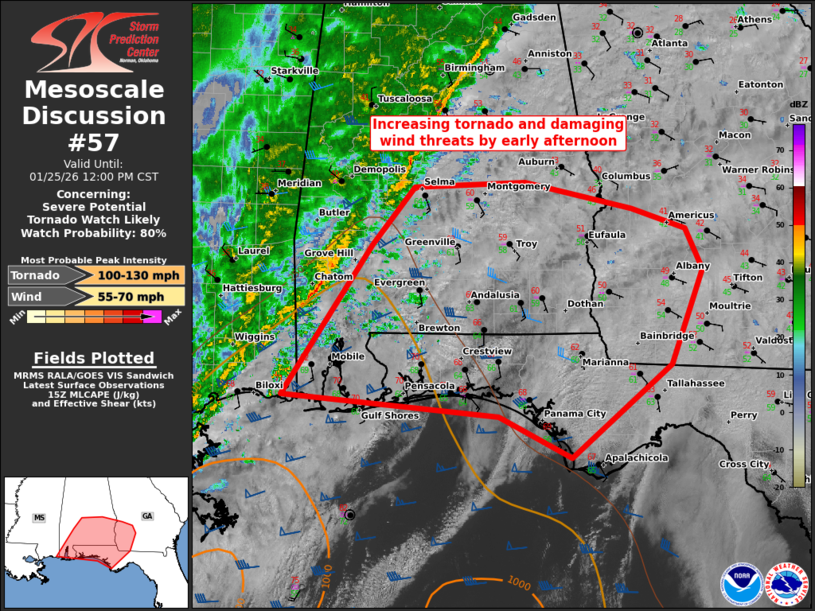
   Areas affected...southern AL...FL Panhandle...southwest GA

   Concerning...Severe potential...Tornado Watch likely

   Valid 251555Z - 251800Z

   Probability of Watch Issuance...80 percent

   SUMMARY...Severe potential will likely increase into early afternoon
   with a QLCS and embedded supercells capable of producing damaging
   winds and tornadoes. A tornado watch will likely be needed.

   DISCUSSION...Along a pronounced cold front to the south-southwest of
   a surface cyclone between TCL and SEM, convective intensities appear
   to be increasing to the central Gulf Coast. Pre-frontal cells have
   also increased over the past hour, and an increasing severe threat
   is anticipated as activity matures over the next 2-3 hours. While
   pervasive downstream cloud coverage is limiting boundary-layer
   heating in the confined warm-moist sector, 60s surface dew points
   are sufficient for weak to modest MLCAPE from Mobile Bay and the
   western FL Panhandle northward into south-central AL. This
   warm-moist sector will shift east through the afternoon and likely
   reach southwest GA to the eastern FL Panhandle. Low-level shear is
   quite strong with enlarged hodographs favoring
   mesocyclone/mesovortex development. Expectation is for a QLCS to
   evolve east through the afternoon with a threat for damaging winds
   and brief tornadoes. If semi-discrete supercells can form ahead of
   and merge into the QLCS, a longer-tracked tornado or two is
   possible.

   ..Grams/Hart.. 01/25/2026

   ...Please see www.spc.noaa.gov for graphic product...

   ATTN...WFO...FFC...TAE...BMX...MOB...LIX...

   LAT...LON   30388857 31858758 32418709 32478584 32218462 32008402
               31608382 30688419 29788531 30188614 30388857

   MOST PROBABLE PEAK TORNADO INTENSITY...100-130 MPH
   MOST PROBABLE PEAK WIND GUST...55-70 MPH
|
|
|
Top/All Mesoscale Discussions/Forecast Products/Home |
|
Source link


