| Mesoscale Discussion 53 | |
| < Previous MD | |

|
|
Mesoscale Discussion 0053
NWS Storm Prediction Center Norman OK
0123 AM CST Sun Jan 25 2026
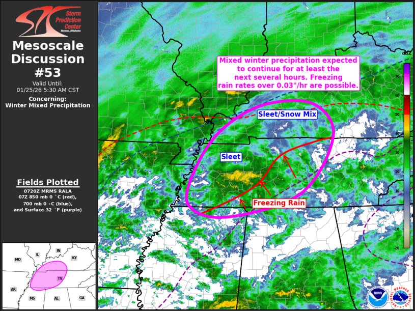
Areas affected...Far Northern MS...Western/Middle TN...Southwest KY
Concerning...Winter mixed precipitation
Valid 250723Z - 251130Z
SUMMARY...Mixed winter precipitation is expected to continue for at
least the next several hours from northern MS across western/middle
TN and into southwest KY for the next several hours. Freezing rain
rates over 0.03"/hour are possible.
DISCUSSION...Regional radar imagery has shown a notable increase in
reflectivity across western TN over the past half hour. Based on
radar data from KNQA, this area of increased reflectivity is
occurring between 3000 and 4000 ft, which is near where refreezing
into sleet would occur based on area forecast soundings.
Consequently, this increased reflectivity is likely more related to
bright band effects than increasing precipitation rates, while also
indicating where the transition zone from freezing rain to sleet is
currently located.
Expectation is for this transition zone to drift
northward/northwestward over the next few hours as the warm nose
increases slightly amid continued warm-air advection. This warm-air
advection will also foster continued precipitation, confirmed by
regional radar imagery showing widespread upstream precipitation.
All of these factors suggest that mixed winter precipitation will
continue from northern MS across western/middle TN and into
southwest KY for the next several hours. Freezing rain rates up to
0.03"/hr. have already been observed at BNA, with similar (and
higher) rates possible over the next few hours, particularly over
western TN.
..Mosier.. 01/25/2026
...Please see www.spc.noaa.gov for graphic product...
ATTN...WFO...LMK...OHX...HUN...PAH...MEG...
LAT...LON 35938959 36848885 37428764 37458617 36678557 35328654
34758871 35058981 35938959
|
|
|
Top/All Mesoscale Discussions/Forecast Products/Home |
|
Source link