| Mesoscale Discussion 50 | |
| < Previous MD Next MD > | |

|
|
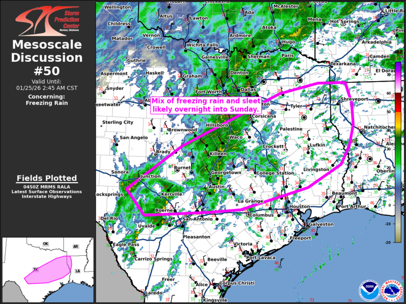
   Mesoscale Discussion 0050
   NWS Storm Prediction Center Norman OK
   1052 PM CST Sat Jan 24 2026

   Areas affected...portions of south-central/eastern Texas into
   western Louisiana

   Concerning...Freezing rain

   Valid 250452Z - 250845Z

   SUMMARY...Mix of freezing rain and sleet likely overnight into early
   Sunday.

   DISCUSSION...Freezing rain and occasional sleet has been ongoing
   from the San Antonio Metro to College Station, TX. There are reports
   of freezing rain accumulations around 0.05-0.10 of an inch in 3
   hours. Guidance indicates that coverage of precipitation will
   increase over the next several hours across south-central Texas into
   western Louisiana as large scale ascent continues to increase.

   Forecast RAP soundings depict a warm layer around 850 mb above more
   shallow sub-freezing air near the surface supporting the primary
   precipitation type to be freezing rain. HREF guidance indicates
   increasing probabilities of at least 0.05 of an inch per 3 hr
   freezing rainfall rates along and north of the I-10 corridor
   overnight into early Sunday morning. Sleet will remain possible at
   times in heavier bands, especially with further north extent into
   the deeper cold air across northeastern Texas.

   ..Thornton.. 01/25/2026

   ...Please see www.spc.noaa.gov for graphic product...

   ATTN...WFO...LCH...SHV...HGX...FWD...EWX...SJT...

   LAT...LON   33029441 33029358 32499340 31919337 31389351 30919376
               30329476 29769676 29709764 29579959 30230014 31389854
               32759559 33029441
|
|
|
Top/All Mesoscale Discussions/Forecast Products/Home |
|
Source link