| Mesoscale Discussion 48 | |
| < Previous MD | |
|
|
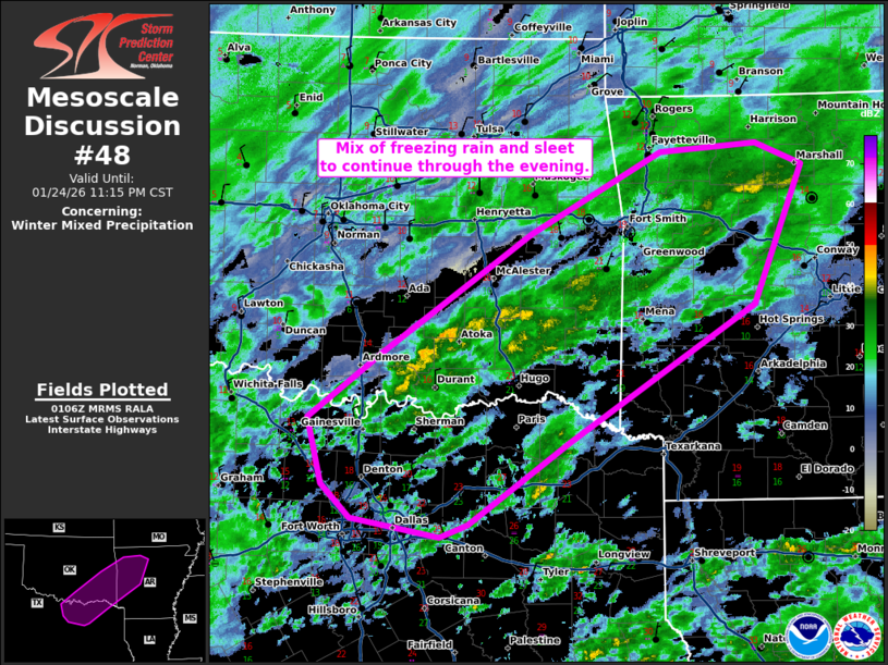
   Mesoscale Discussion 0048
   NWS Storm Prediction Center Norman OK
   0709 PM CST Sat Jan 24 2026

   Areas affected...north-central Texas...southeastern
   Oklahoma...western Arkansas

   Concerning...Winter mixed precipitation

   Valid 250109Z - 250515Z

   SUMMARY...Mix of freezing rain and sleet to continue through the
   evening.

   DISCUSSION...Surface observations have reported periods of sleet and
   freezing rain across north-central Texas into southeastern Oklahoma
   and into western Arkansas. Freezing rain accumulations have
   generally been around 0.01"/hr or less. Sleet accumulations near the
   Dallas Metro around 0.10-0.50"/hr. 00z soundings from FWD and LZK
   show a warm nose across between 850-700 mb atop sub-freezing surface
   temperatures.

   As upper-level forcing for ascent increases with the ejecting low, a
   mix of freezing rain and sleet can be expected to continue across
   this region through the next several hours. The primary
   precipitation type is expected to be sleet, with areas of freezing
   rain/mist. Freezing rain amounts should be generally less than
   0.01"/hr with sleet accumulations around 0.10-0.50"/hr.

   ..Thornton.. 01/25/2026

   ...Please see www.spc.noaa.gov for graphic product...

   ATTN...WFO...LZK...SHV...TSA...FWD...OUN...

   LAT...LON   33729769 34289693 35319539 36019403 36089303 35909255
               34709306 33529499 32809604 32699632 32869724 33159755
               33729769
|
|
|
Top/All Mesoscale Discussions/Forecast Products/Home |
|
Source link