| Mesoscale Discussion 416 | |
| < Previous MD | |
|
|
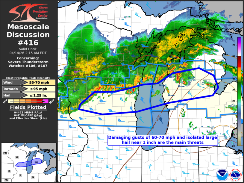
Mesoscale Discussion 0416 NWS Storm Prediction Center Norman OK 1143 PM CDT Mon Apr 13 2026 Areas affected...2Southern Wisconsin into central Lower Michigan Concerning...Severe Thunderstorm Watch 106...107... Valid 140443Z - 140615Z The severe weather threat for Severe Thunderstorm Watch 106, 107 continues. SUMMARY...Occasional damaging gusts of 60-70 mph and isolated large hail near 1 inch in diameter will be possible along the conglomerate outflow through 06z. DISCUSSION...Thunderstorms have grown upscale into an extensive QLCS with a conglomerate cold pool extending from northeast IA across southern WI and into central Lower MI. The predominately east-west orientation of the QLCS in westerly flow aloft suggests that most of the stronger updrafts will remain slightly to the cool side of the southeast-moving outflow. A few smaller scale bowing segments will be possible, especially with cell mergers into the line, which is more probable across central Lower MI. Occasional damaging outflow gusts of 60-70 mph and hail near 1 inch in diameter will be the main threats through at least 06z. ..Thompson.. 04/14/2026 ...Please see www.spc.noaa.gov for graphic product... ATTN...WFO...DTX...APX...GRR...GRB...MKX...ARX... LAT...LON 43018778 42908947 43069064 43239059 43698990 43728895 43798849 43998750 44048675 44408601 44578467 44308394 43868373 43588401 43348622 43018778 MOST PROBABLE PEAK TORNADO INTENSITY...UP TO 95 MPH MOST PROBABLE PEAK WIND GUST...55-70 MPH MOST PROBABLE PEAK HAIL SIZE...UP TO 1.25 IN |
|
|
Top/All Mesoscale Discussions/Forecast Products/Home |
|
Source link