| Mesoscale Discussion 414 | |
| < Previous MD | |

|
|
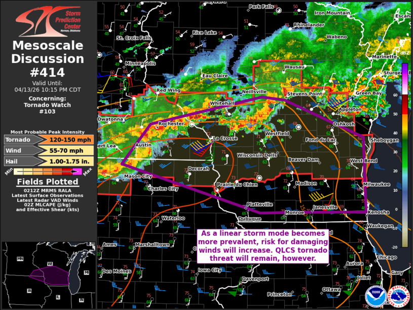
Mesoscale Discussion 0414 NWS Storm Prediction Center Norman OK 0915 PM CDT Mon Apr 13 2026 Areas affected...Southeast Minnesota into southern Wisconsin Concerning...Tornado Watch 103... Valid 140215Z - 140315Z The severe weather threat for Tornado Watch 103 continues. SUMMARY...A replacement for the 03Z expiring WW 103 is expected soon. Damaging winds will become more of threat with time, but the threat for tornadoes will still be a concern into the overnight given the strong low-level shear. DISCUSSION...Ongoing convection across the Upper Midwest has generally become more linear over the past few hours. The increase of the low-level jet (50+ kts observed on the KMKX VAD) suggests that buoyant inflow will be sustained as storms move south and east into the overnight period. The threat for damaging winds will likely be on the increase as linear segments continue to organize and low-level flow remains strong. The tornado threat has decreased somewhat due to a less favorable storm mode. Even so, the KMKX VAD has a notable 700+ 0-1 km SRH. The potential for tornadoes will still be concern both with QLCS circulations and any discrete storms that may form ahead of the linear segments. WW 103 is set to expire at 03Z and a replacement watch will need to be issued soon. ..Wendt.. 04/14/2026 ...Please see www.spc.noaa.gov for graphic product... ATTN...WFO...GRB...MKX...ARX...MPX...DMX... LAT...LON 43409324 44069262 44539011 44488961 43858785 42638782 42648814 42668917 42659015 43409324 MOST PROBABLE PEAK TORNADO INTENSITY...120-150 MPH MOST PROBABLE PEAK WIND GUST...55-70 MPH MOST PROBABLE PEAK HAIL SIZE...1.00-1.75 IN |
|
|
Top/All Mesoscale Discussions/Forecast Products/Home |
|
Source link