| Mesoscale Discussion 413 | |
| < Previous MD | |

|
|
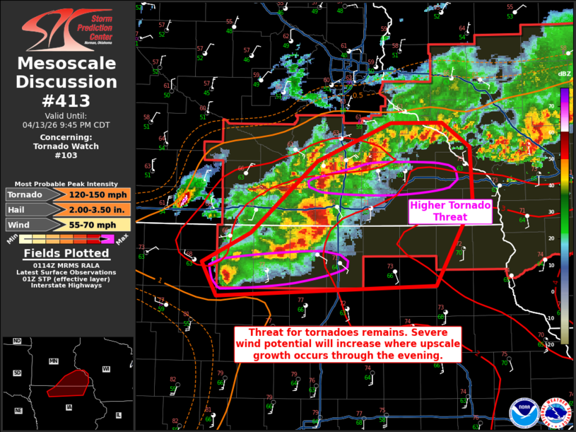
Mesoscale Discussion 0413 NWS Storm Prediction Center Norman OK 0816 PM CDT Mon Apr 13 2026 Areas affected...Far northern Iowa into southeast Minnesota Concerning...Tornado Watch 103... Valid 140116Z - 140245Z The severe weather threat for Tornado Watch 103 continues. SUMMARY...Areas near the warm front in southeast Minnesota and on the southern end of ongoing activity in north-central Iowa will see the greatest tornado risk over the next couple of hours. Large/very-large hail will be possible with supercells. Severe wind potential will increase with upscale growth that occurs. DISCUSSION...Strong low-level shear is noted on VAD data from KDMX and KARX. As nocturnal cooling should remain slow on account of theta-e advection, low-level thermodynamic profiles will remain supportive of tornadoes for another 3-4 hours or so. The main areas of tornado risk will be along the warm front in southeast Minnesota as well as a isolated supercell on the southern flank of the activity in north-central Iowa. In between these areas, storms have consolidated and grown upscale. This will pose a risk for additional QLCS circulations as well as severe winds. Large to very-large hail remains possible with the most discrete cells. ..Wendt.. 04/14/2026 ...Please see www.spc.noaa.gov for graphic product... ATTN...WFO...ARX...MPX...DMX...FSD... LAT...LON 42829492 43149510 43429448 44109361 44479265 44469198 44239163 43719160 42939208 42829492 MOST PROBABLE PEAK TORNADO INTENSITY...120-150 MPH MOST PROBABLE PEAK WIND GUST...55-70 MPH MOST PROBABLE PEAK HAIL SIZE...2.00-3.50 IN |
|
|
Top/All Mesoscale Discussions/Forecast Products/Home |
|
Source link