| Mesoscale Discussion 412 | |
| < Previous MD | |

|
|
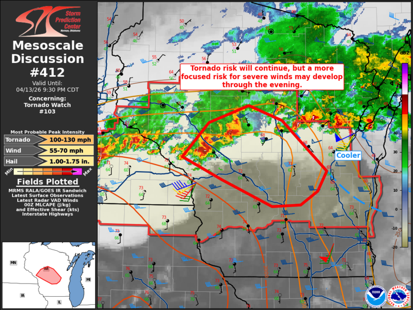
Mesoscale Discussion 0412 NWS Storm Prediction Center Norman OK 0757 PM CDT Mon Apr 13 2026 Areas affected...West-central into central Wisconsin Concerning...Tornado Watch 103... Valid 140057Z - 140230Z The severe weather threat for Tornado Watch 103 continues. SUMMARY...A threat for tornadoes will continue into the evening as low-level shear increases. Furthermore, upscale growth of ongoing supercells will also lead to an increase threat for severe winds. DISCUSSION...Two supercells are ongoing west and northeast of Black River Falls. The high-precipitation character of these storms has become more apparent over the last couple of hours. The storm west of BRF shows a strong, but broad mesocyclone along with a strong rear flank downdraft signal on radar. With continued warm advection and upscale growth, an increasing threat for severe winds may develop as they progress east-southeast. To the east, cooler air is noted in surface observations which would suggest the strongest activity may turn slightly southward into greater buoyancy. The tornado threat will continue, however, as large low-level hodographs are evident on KARX and KMKX. Large hail could occur on an isolated basis, but storm mode will likely become less favorable with time. ..Wendt.. 04/14/2026 ...Please see www.spc.noaa.gov for graphic product... ATTN...WFO...GRB...MKX...ARX...MPX... LAT...LON 44189145 44659094 44909017 44698951 43988866 43698884 43508916 43488972 43859068 44189145 MOST PROBABLE PEAK TORNADO INTENSITY...100-130 MPH MOST PROBABLE PEAK WIND GUST...55-70 MPH MOST PROBABLE PEAK HAIL SIZE...1.00-1.75 IN |
|
|
Top/All Mesoscale Discussions/Forecast Products/Home |
|
Source link