| Mesoscale Discussion 407 | |
| < Previous MD | |

|
|
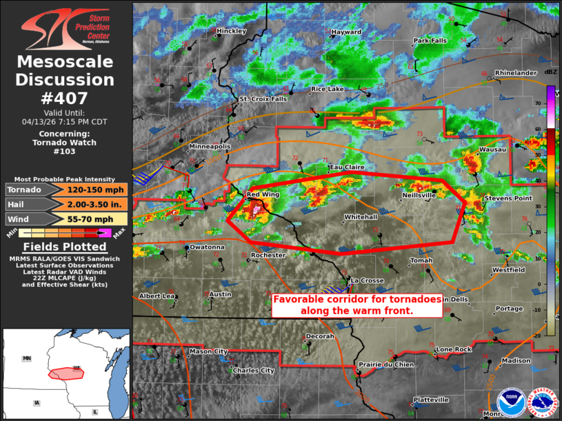
Mesoscale Discussion 0407 NWS Storm Prediction Center Norman OK 0546 PM CDT Mon Apr 13 2026 Areas affected...Portions of Coulee region into central Wisconsin Concerning...Tornado Watch 103... Valid 132246Z - 140015Z The severe weather threat for Tornado Watch 103 continues. SUMMARY...A favorable corridor for tornadoes will exist along the warm front over the next 2-3 hours. As additional storms form this evening, storm interference may eventually modulate the tornado threat. Large to very-large hail is also possible. DISCUSSION...A favorable corridor for tornadoes exists along the warm front from west-central Wisconsin into central Wisconsin. Here, low-level shear will be maximized and will likely increase early this evening as 850 mb winds intensify. The strongest storm is currently along the Goodhue/Wabasha County line. This storm poses the greatest threat for large/very-large hail and tornadoes in the near term. The main question will be whether a storm can become dominant and move along the warm front. There will likely be a window during the next 2-3 hours where this is possible. Beyond that time, increasing low-level warm advection will probably promote additional storms and storm interactions will make the tornado risk less clear. ..Wendt.. 04/13/2026 ...Please see www.spc.noaa.gov for graphic product... ATTN...WFO...GRB...ARX...MPX... LAT...LON 44379275 44669244 44819121 44739007 44528979 44178996 44079133 44179245 44379275 MOST PROBABLE PEAK TORNADO INTENSITY...120-150 MPH MOST PROBABLE PEAK WIND GUST...55-70 MPH MOST PROBABLE PEAK HAIL SIZE...2.00-3.50 IN |
|
|
Top/All Mesoscale Discussions/Forecast Products/Home |
|
Source link