| Mesoscale Discussion 402 | |
| < Previous MD Next MD > | |

|
|
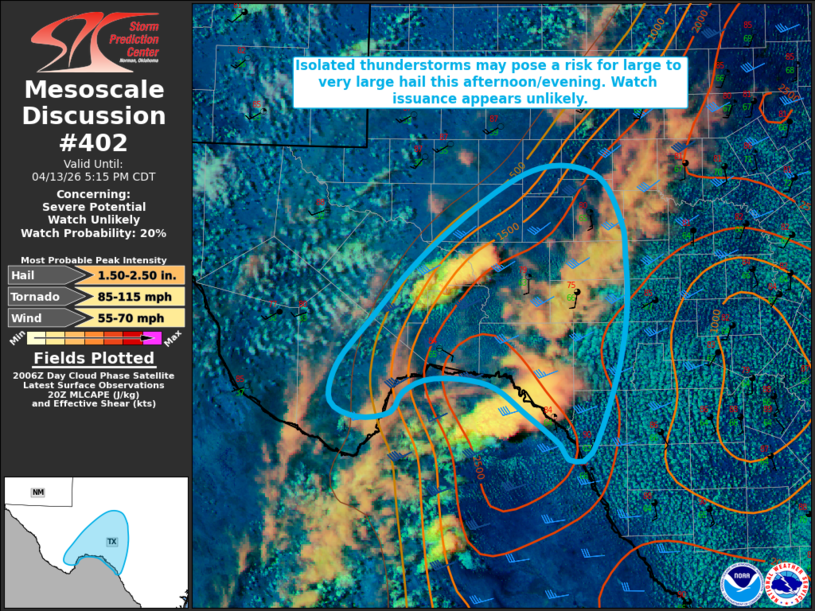
   Mesoscale Discussion 0402
   NWS Storm Prediction Center Norman OK
   0311 PM CDT Mon Apr 13 2026

   Areas affected...portion of the Texas Big Bend into Edward Plateau

   Concerning...Severe potential...Watch unlikely

   Valid 132011Z - 132215Z

   Probability of Watch Issuance...20 percent

   SUMMARY...Isolated thunderstorm development is ongoing across
   portions of southwest Texas/northern Mexico, with large to very
   large hail and severe wind gusts the primary threats.

   DISCUSSION...Latest radar and GLM Flash data depict isolated
   thunderstorm development across Stockton Plateau in southwest Texas
   and the Sierra del Carmen in northern Mexico. Surface temperatures
   in the upper-70s and dewpoints in the mid-60s F ahead of an
   approaching dryline are supporting 2000-3000+ J/kg MLCAPE. Straight,
   elongated hodographs amid 30-40 kts of effective bulk shear and
   steep mid-level lapse rates of 7+ C/km (per latest mesoanalysis)
   will support supercells capable of large to very large hail and
   severe wind gusts. A tornado or two cannot be ruled out should a
   supercell persist into the late evening hours as the nocturnal
   low-level jet strengths, supporting some increase in low-level
   shear/hodograph curvature. Watch issuance appears unlikely at this
   time owing to the expected isolated storm coverage. Trends will
   continue to be monitored, and a watch may be needed should the
   threat magnitude/coverage trend higher.

   ..Chalmers/Hart.. 04/13/2026

   ...Please see www.spc.noaa.gov for graphic product...

   ATTN...WFO...EWX...SJT...MAF...

   LAT...LON   29510342 29870336 30300300 30960236 31600151 31820091
               31710039 31270014 30950010 30420008 29750021 29000050
               28940075 29090084 29380121 29670165 29730226 29610260
               29410274 29350312 29510342

   MOST PROBABLE PEAK TORNADO INTENSITY...85-115 MPH
   MOST PROBABLE PEAK WIND GUST...55-70 MPH
   MOST PROBABLE PEAK HAIL SIZE...1.50-2.50 IN
|
|
|
Top/All Mesoscale Discussions/Forecast Products/Home |
|
Source link