| Mesoscale Discussion 401 | |
| < Previous MD Next MD > | |

|
|
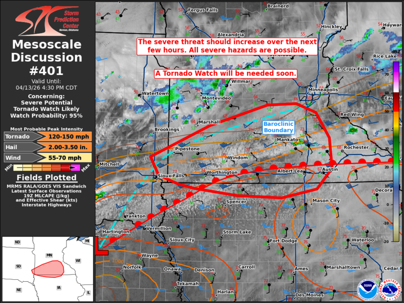
   Mesoscale Discussion 0401
   NWS Storm Prediction Center Norman OK
   0259 PM CDT Mon Apr 13 2026

   Areas affected...portions of extreme southeastern South Dakota into
   extreme northern Iowa and southern Minnesota

   Concerning...Severe potential...Tornado Watch likely

   Valid 131959Z - 132130Z

   Probability of Watch Issuance...95 percent

   SUMMARY...The severe threat will increase along and to the north of
   a warm front over the next few hours. Severe wind/hail and at least
   a few tornadoes are possible. A couple of strong tornadoes may
   occur. A Tornado Watch is being issued.

   DISCUSSION...As widespread stratiform clouds erode in proximity to a
   warm front, MLCINH will continue to decrease, which is already
   supporting the development of a CU field between the primary warm
   front (where richer moisture is in place along the MN/IA border),
   and a differential heating boundary to the north in southern MN.
   Over 2000 J/kg MLCAPE and 50 kts of effective bulk shear is in
   place, which will support supercell structures capable of severe
   wind and hail. Severe hail is possible with any storms along the
   warm front or near the differential heating boundary, with 2+ inch
   hail possible. Tornadoes will also be possible with supercells
   anchoring to the warm front. Should a more dominant, discrete
   supercell sustain along the warm front, strong tornadoes will become
   possible. A Tornado Watch will be issued soon.

   ..Squitieri/Hart.. 04/13/2026

   ...Please see www.spc.noaa.gov for graphic product...

   ATTN...WFO...ARX...MPX...DMX...FSD...

   LAT...LON   43929685 44459550 44789417 44819352 44659307 44239276
               43749272 43409307 43269386 43309488 43409583 43489621
               43619666 43929685

   MOST PROBABLE PEAK TORNADO INTENSITY...120-150 MPH
   MOST PROBABLE PEAK WIND GUST...55-70 MPH
   MOST PROBABLE PEAK HAIL SIZE...2.00-3.50 IN
|
|
|
Top/All Mesoscale Discussions/Forecast Products/Home |
|
Source link