|
|
| Mesoscale Discussion 399 | |
| < Previous MD | |

|
|
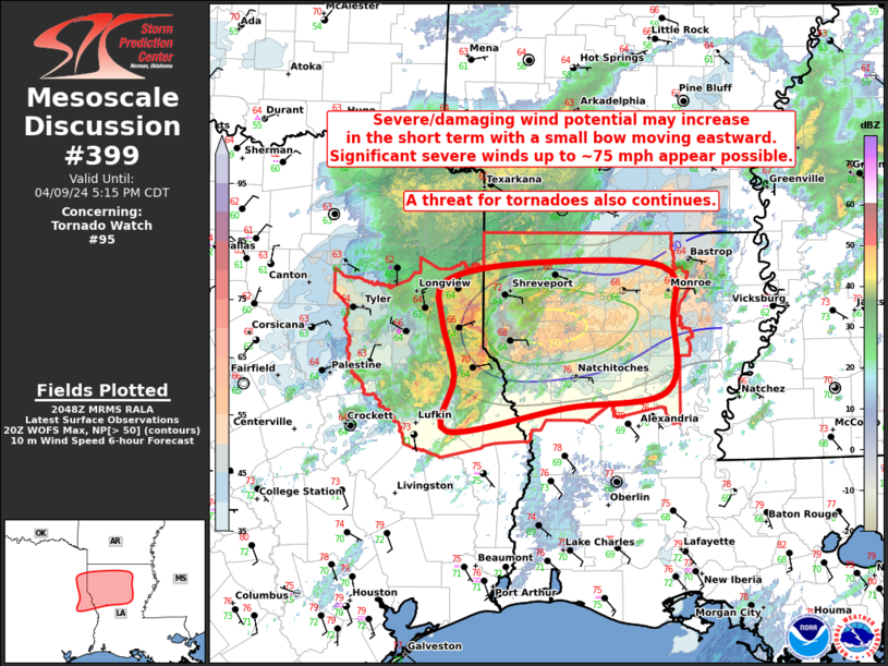
Mesoscale Discussion 0399 NWS Storm Prediction Center Norman OK 0350 PM CDT Tue Apr 09 2024 Areas affected...Portions of far east TX into western/northern LA Concerning...Tornado Watch 95... Valid 092050Z - 092215Z The severe weather threat for Tornado Watch 95 continues. SUMMARY...Severe/damaging wind potential may increase in the short term with a small bow moving eastward across parts of western/northern Louisiana. Significant severe winds up to around 75 mph appear possible. DISCUSSION...A small bowing complex continues to organize across far east TX into far western LA. Even with cloud cover remaining prevalent downstream into northern LA, gradual airmass destabilization is occurring along and north of a surface boundary. Around 500-1000 J/kg of MLCAPE will likely be sufficient to maintain current thunderstorm intensities, and strong deep-layer shear will be more than enough for continued convective organization with the bow. Recent Warn on Forecast (WoF) output shows increasing potential (greater than 50% chance) for severe-caliber winds of 50 kt or greater with this bow as it spreads eastward across parts of northern LA over the next couple of hours. Some chance for significant severe winds up to around 75 mph also appears possible. With ample 0-1 km shear present, and low-level winds backed to easterly along/near the surface boundary, a tornado threat will also exist. The best chance for a tornado will probably remain focused with embedded circulations within the bow, and along the surface boundary. ..Gleason.. 04/09/2024 ...Please see www.spc.noaa.gov for graphic product... ATTN...WFO...SHV... LAT...LON 32249446 32599442 32749359 32719218 32269206 31609214 31479318 31269441 31749433 32249446 |
|
|
Top/All Mesoscale Discussions/Forecast Products/Home |
|


