| Mesoscale Discussion 392 | |
| < Previous MD | |
|
|
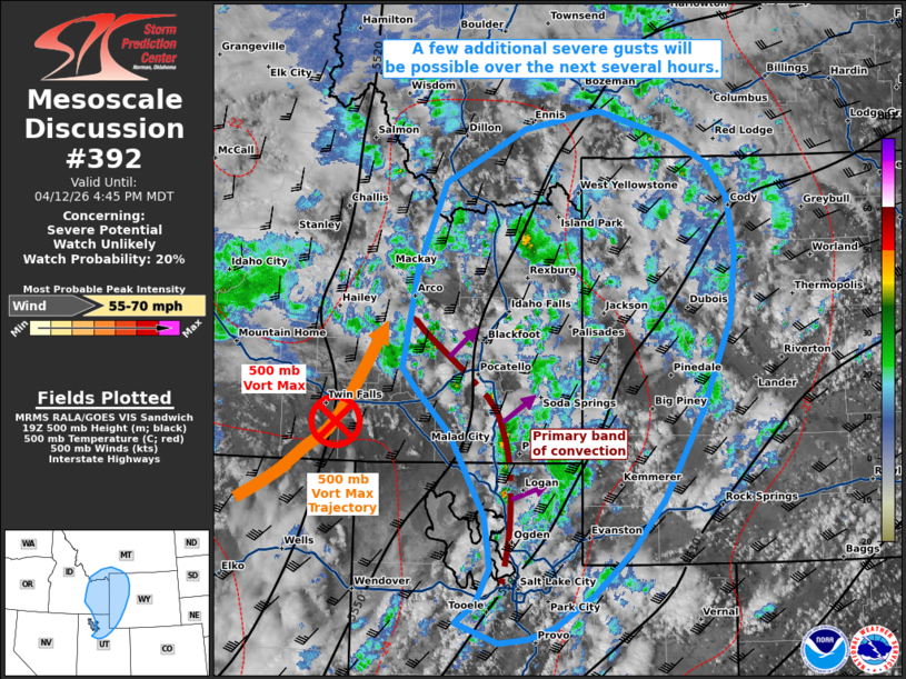
   Mesoscale Discussion 0392
   NWS Storm Prediction Center Norman OK
   0348 PM CDT Sun Apr 12 2026

   Areas affected...portions of eastern Idaho...northern Utah...western
   Wyoming...far southern Montana

   Concerning...Severe potential...Watch unlikely

   Valid 122048Z - 122245Z

   Probability of Watch Issuance...20 percent

   SUMMARY...A few more severe gusts may occur with the stronger storms
   over the next few hours, especially in association with the primary
   band of convection over southeastern ID into northern UT.

   DISCUSSION...Scattered thunderstorms have developed over portions of
   the central Rockies over the past few hours with the approach of a
   500 mb vort max. A relatively more pronounced band of thunderstorms
   has become established over southeastern ID into northern UT, where
   multiple 50+ kt convective wind gusts have been measured. Given up
   to 1000 J/kg SBCAPE preceding this convective band (per 20Z
   mesoanalysis), additional severe gusts remain possible, both with
   this band, and perhaps with storms out ahead of it

   ..Squitieri/Mosier.. 04/12/2026

   ...Please see www.spc.noaa.gov for graphic product...

   ATTN...WFO...BYZ...RIW...TFX...SLC...PIH...MSO...

   LAT...LON   40421270 40601245 40961226 41461234 42271280 42711327
               42911344 43901326 44741289 45271182 45451081 45190984
               44930934 44610907 44070898 43410905 42500944 41640995
               41121037 40701088 40371138 40261175 40211213 40421270

   MOST PROBABLE PEAK WIND GUST...55-70 MPH
|
|
|
Top/All Mesoscale Discussions/Forecast Products/Home |
|
Source link