|
|
| Mesoscale Discussion 391 | |
| < Previous MD | |
|
|
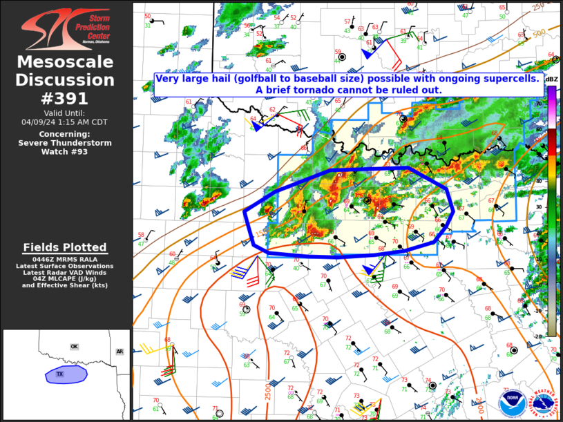
Mesoscale Discussion 0391 NWS Storm Prediction Center Norman OK 0418 AM CDT Fri Apr 04 2025 Areas affected...ern OK...nwrn AR...swrn MO Concerning...Severe Thunderstorm Watch 111... Valid 040918Z - 041115Z The severe weather threat for Severe Thunderstorm Watch 111 continues. SUMMARY...Strong thunderstorm development will continue to rapidly spread east-northeastward toward the northeastern Oklahoma into southwestern Missouri Interstate 44 corridor, with a few cells posing a risk for severe hail. Trends are being monitored for the possibility of an additional severe weather watch. DISCUSSION...Strongest lower/mid-tropospheric forcing for ascent ahead of a short wave perturbation progressing northeast of the Texas South Plains is forecast to rapidly spread northeast of the Red River toward the Ozark Plateau through daybreak. This includes lift associated with warm advection near the northern periphery of a plume of more strongly capping elevated mixed-layer, which may also spread north of the Red River through 11-13Z. As this occurs, strongest thunderstorms may tend to redevelop north-northeastward into the Interstate 44 vicinity of northeastern Oklahoma into southwestern Missouri, where similar thermodynamic and convective layer shear profiles as upstream may support a continuing risk for severe hail. ..Kerr.. 04/04/2025 ...Please see www.spc.noaa.gov for graphic product... ATTN...WFO...LZK...SGF...SHV...TSA...FWD...OUN... LAT...LON 36339593 37199321 36069269 34639485 33899592 33989758 34889773 36339593 MOST PROBABLE PEAK WIND GUST...UP TO 60 MPH MOST PROBABLE PEAK HAIL SIZE...1.50-2.50 IN |
|
|
Top/All Mesoscale Discussions/Forecast Products/Home |
|
Source link