| Mesoscale Discussion 388 | |
| < Previous MD Next MD > | |
|
|
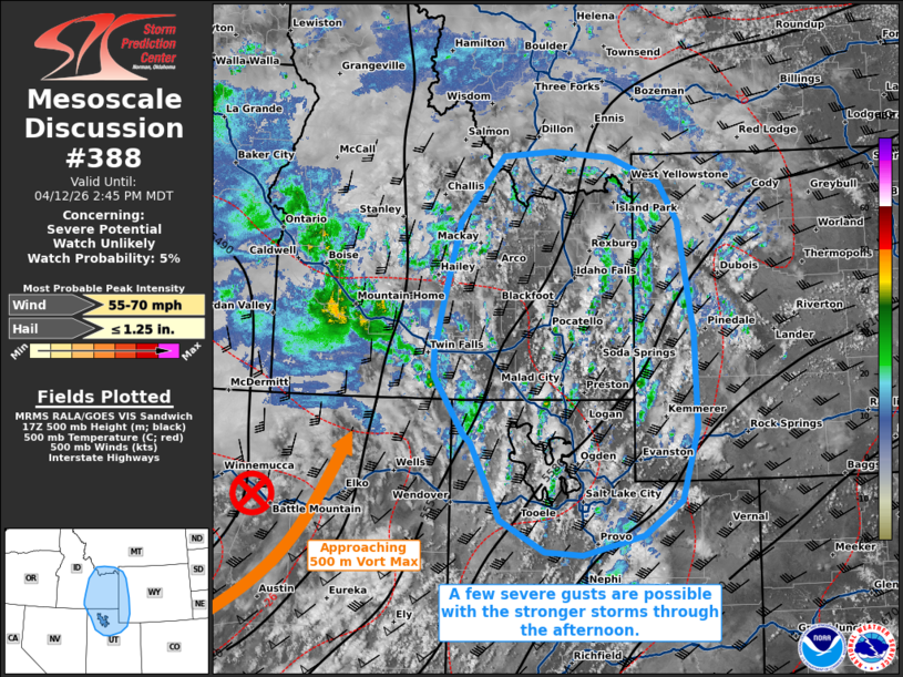
   Mesoscale Discussion 0388
   NWS Storm Prediction Center Norman OK
   0140 PM CDT Sun Apr 12 2026

   Areas affected...portions of northern Utah into eastern Idaho...far
   western Wyoming...extreme southwestern Montana

   Concerning...Severe potential...Watch unlikely

   Valid 121840Z - 122045Z

   Probability of Watch Issuance...5 percent

   SUMMARY...A few severe gusts may occur with the strongest storms
   that can mature over the next several hours. The severe threat
   should remain isolated.

   DISCUSSION...Clearing skies are supporting boundary-layer
   mixing/destabilization amid the approach of a 500 mb vort max,
   resulting in increased lift for convective development. Visible
   satellite imagery depicts deepening CU, with NLDN lightning data
   already showing a few lightning flashes in spots. Storms should
   continue to increase in coverage and intensity through the afternoon
   given 8+ C/km mid-level lapse rates amid 30 kts of effective bulk
   shear. Storms should be mainly multicellular, the strongest of which
   may be accompanied by occasional strong wind gusts (a few of which
   may be severe, especially in higher-terrain areas), and perhaps an
   instance or two of hail. Given the modest speed shear, the severe
   threat should remain isolated at best, so a WW issuance is not
   expected.

   ..Squitieri/Mosier.. 04/12/2026

   ...Please see www.spc.noaa.gov for graphic product...

   ATTN...WFO...RIW...TFX...SLC...PIH...MSO...BOI...LKN...

   LAT...LON   41451373 41571385 42281435 42551434 43131422 44151393
               44961322 45031241 44951142 44651061 44171030 42791005
               41641001 40751026 40321090 40091188 40131251 40511325
               41451373

   MOST PROBABLE PEAK WIND GUST...55-70 MPH
   MOST PROBABLE PEAK HAIL SIZE...UP TO 1.25 IN
|
|
|
Top/All Mesoscale Discussions/Forecast Products/Home |
|
Source link