| Mesoscale Discussion 385 | |
| < Previous MD | |

|
|
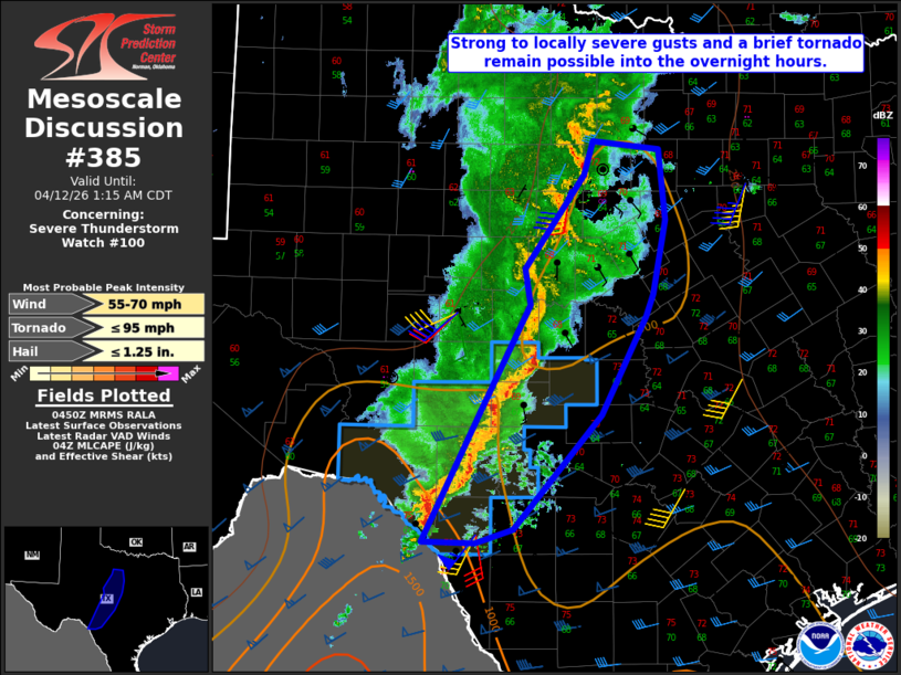
Mesoscale Discussion 0385 NWS Storm Prediction Center Norman OK 1152 PM CDT Sat Apr 11 2026 Areas affected...Edwards Plateau into parts of north-central TX Concerning...Severe Thunderstorm Watch 100... Valid 120452Z - 120615Z The severe weather threat for Severe Thunderstorm Watch 100 continues. SUMMARY...Strong to locally severe gusts and a brief tornado remain possible into the overnight hours. DISCUSSION...A loosely organized QLCS has evolved across parts of Edwards Plateau, with multiple embedded bowing segments noted from east of San Angelo to north of Del Rio. Organized storm structures are expected to persist into the early overnight hours, given favorable moisture, effective SRH (generally in the 100-200 m2/s2 range) and moderate deep-layer shear. However, the magnitude of the threat may be tempered to some extent by the modest buoyancy (MLCAPE of 500-1000 J/kg) and weak low-level lapse rates. Strong to locally severe gusts will continue to be possible with any persistent bowing segments, and a brief tornado cannot be ruled out given the presence of sufficient low-level shear. Some severe threat may develop east and north of WW 100, though the need for local watch expansion or new watch issuance will be dependent on short-term observational trends regarding convective vigor and organization into the early morning. ..Dean/Thompson.. 04/12/2026 ...Please see www.spc.noaa.gov for graphic product... ATTN...WFO...FWD...EWX...SJT... LAT...LON 29490071 30430023 31449968 31789975 32669910 32999899 32919826 32249819 31539833 31339842 30409891 29319987 29180027 29190086 29490071 MOST PROBABLE PEAK TORNADO INTENSITY...UP TO 95 MPH MOST PROBABLE PEAK WIND GUST...55-70 MPH MOST PROBABLE PEAK HAIL SIZE...UP TO 1.25 IN |
|
|
Top/All Mesoscale Discussions/Forecast Products/Home |
|
Source link