| Mesoscale Discussion 380 | |
| < Previous MD | |

|
|
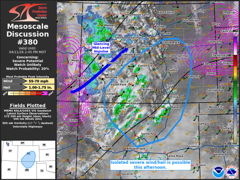
   Mesoscale Discussion 0380
   NWS Storm Prediction Center Norman OK
   0141 PM CDT Sat Apr 11 2026

   Areas affected...portions of central Colorado into northern New
   Mexico

   Concerning...Severe potential...Watch unlikely

   Valid 111841Z - 112045Z

   Probability of Watch Issuance...20 percent

   SUMMARY...A couple instances of severe wind or hail are possible
   with the stronger storms moving off of the higher terrain.

   DISCUSSION...Afternoon peak heating, the approach of an embedded
   mid-level impulse, and orographic lift, are all contributing to
   thunderstorm initiation and increasing coverage across portions of
   southern CO into northern NM. 40+ kts of southwesterly mid-level
   flow are overspreading the region, contributing to elongated
   hodographs and 30-40 kts of effective bulk shear (per 18Z
   mesoanalysis/ABQ observed sounding). With 8+ C/km low- and mid-level
   lapse rates supporting close to 1000 J/kg of tall and thin SBCAPE,
   multicells should continue to develop through the day, accompanied
   by at least some risk for severe wind and hail. The severe threat
   should be isolated, with a WW not anticipated.

   ..Squitieri/Mosier.. 04/11/2026

   ...Please see www.spc.noaa.gov for graphic product...

   ATTN...WFO...PUB...BOU...ABQ...GJT...

   LAT...LON   35230609 36090723 36670771 37480781 38520675 39210560
               39570474 39620406 39300354 38760332 38030337 37120361
               36340395 35560474 35230609

   MOST PROBABLE PEAK WIND GUST...55-70 MPH
   MOST PROBABLE PEAK HAIL SIZE...1.00-1.75 IN
|
|
|
Top/All Mesoscale Discussions/Forecast Products/Home |
|
Source link