|
|
| Mesoscale Discussion 367 | |
| < Previous MD | |
|
|
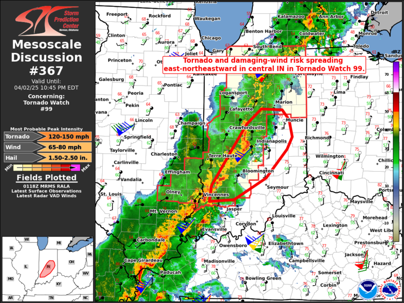
Mesoscale Discussion 0367 NWS Storm Prediction Center Norman OK 0820 PM CDT Wed Apr 02 2025 Areas affected...Parts of central Indiana Concerning...Tornado Watch 99... Valid 030120Z - 030245Z The severe weather threat for Tornado Watch 99 continues. SUMMARY...The tornado and damaging-wind risk is spreading east-northeastward across central Indiana in Tornado Watch 99. DISCUSSION...The latest radar data from IND/VWX shows an intense bowing line segment with an embedded supercell structure tracking east-northeastward at around 60 kt across central IN. With moist/unstable inflow for this system (middle 60s dewpoints) and 60-70 kt of line-orthogonal 0-6 km shear (pew IND VWP), this intense convection will continue to pose a risk of severe wind gusts (upwards of 80 mph) and embedded tornadoes. Isolated cells developing ahead of the main line will also pose a risk of tornadoes, large hail, and damaging winds. Farther south, semi-discrete supercell clusters are also tracking east-northeastward within a very favorable environment (350-400 m2/s2 effective SRH and around 1500 J/kg MLCAPE). This activity will continue to pose a risk of tornadoes, large hail, and damaging winds as it continues east-northeastward. ..Weinman.. 04/03/2025 ...Please see www.spc.noaa.gov for graphic product... ATTN...WFO...ILN...LMK...IWX...IND... LAT...LON 38618735 38928730 39678676 40188638 40498600 40468544 40268526 39928518 39678533 39098588 38658671 38618735 MOST PROBABLE PEAK TORNADO INTENSITY...120-150 MPH MOST PROBABLE PEAK WIND GUST...65-80 MPH MOST PROBABLE PEAK HAIL SIZE...1.50-2.50 IN |
|
|
Top/All Mesoscale Discussions/Forecast Products/Home |
|
Source link