|
|
| Mesoscale Discussion 366 | |
| < Previous MD | |
|
|
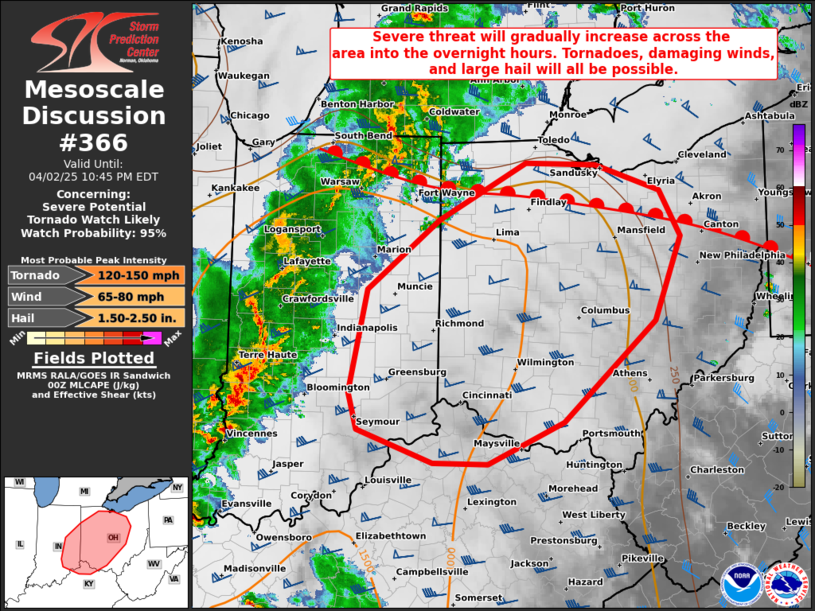
   Mesoscale Discussion 0366
   NWS Storm Prediction Center Norman OK
   0745 PM CDT Wed Apr 02 2025

   Areas affected...Portions of eastern Indiana into western and
   central Ohio

   Concerning...Severe potential...Tornado Watch likely

   Valid 030045Z - 030245Z

   Probability of Watch Issuance...95 percent

   SUMMARY...The severe threat will gradually increase across eastern
   Indiana into western and central Ohio into the overnight hours.
   Tornadoes, damaging winds, and large hail will all be possible. A
   Tornado Watch will be issued within the hour (by 0030Z).

   DISCUSSION...Along/south of an east/west-oriented warm front
   extending across northern IN/OH, an expansive warm/moist sector has
   developed (upper 50 to lower 60s dewpoints). Over the next few
   hours, a 70-80-kt low-level jet (and associated warm advection) will
   overspread the warm sector, promoting a rapid increase in
   surface-based thunderstorm development into the overnight hours. The
   00Z ILN sounding sampled fairly steep deep-layer lapse rates and
   around 1500 J/kg MLCAPE, along with 40 kt of effective shear and a
   large clockwise-curved hodograph (around 350 m2/s2 effective SRH).
   As storms overspread this environment, they should quickly intensify
   into a mix of supercells and organized bowing line segments --
   capable of tornadoes, damaging winds, and large hail. A Tornado
   Watch will be issued for parts of the area within the hour (by
   0030Z).

   ..Weinman/Hart.. 04/03/2025

   ...Please see www.spc.noaa.gov for graphic product...

   ATTN...WFO...PBZ...RLX...CLE...ILN...LMK...IWX...IND...

   LAT...LON   39208596 40238574 40928480 41508368 41478276 41228193
               40768165 39918200 38908318 38488417 38508488 38838586
               39208596

   MOST PROBABLE PEAK TORNADO INTENSITY...120-150 MPH
   MOST PROBABLE PEAK WIND GUST...65-80 MPH
   MOST PROBABLE PEAK HAIL SIZE...1.50-2.50 IN
|
|
|
Top/All Mesoscale Discussions/Forecast Products/Home |
|
Source link