| Mesoscale Discussion 353 | |
| < Previous MD | |

|
|
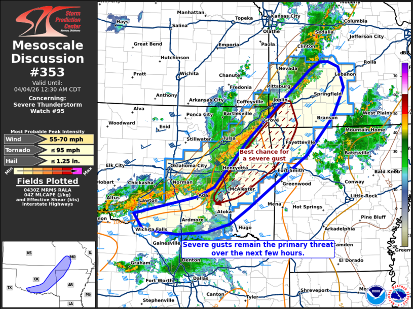
Mesoscale Discussion 0353 NWS Storm Prediction Center Norman OK 1133 PM CDT Fri Apr 03 2026 Areas affected...portions of southwestern Missouri...southern and eastern Oklahoma...northwestern Arkansas Concerning...Severe Thunderstorm Watch 95... Valid 040433Z - 040530Z The severe weather threat for Severe Thunderstorm Watch 95 continues. SUMMARY...Severe gusts remain possible with an expansive MCS over the next few hours. DISCUSSION...A persistent, elongated MCS has materialized from southwest MO to south-central OK over the past few hours, with a progressive embedded bowing feature continuing across east-central OK. This bow has a history of severe gusts, and while the bow has diminished a bit in intensity, severe gusts remain possible given 1000+ J/kg MLCAPE and 35 kts of effective bulk shear remaining in place. A severe gust may also occur wherever a additional bowing structures may materialize, from southwestern MO to southern OK. However, the greatest short-term severe risk remains with the progressive bow. ..Squitieri.. 04/04/2026 ...Please see www.spc.noaa.gov for graphic product... ATTN...WFO...LZK...SGF...TSA...FWD...OUN... LAT...LON 34389852 34829669 35069621 36219521 37879338 38069307 38079282 37949252 37449236 36769269 35829349 35099448 34559519 34179573 33969642 33919726 34019825 34389852 MOST PROBABLE PEAK TORNADO INTENSITY...UP TO 95 MPH MOST PROBABLE PEAK WIND GUST...55-70 MPH MOST PROBABLE PEAK HAIL SIZE...UP TO 1.25 IN |
|
|
Top/All Mesoscale Discussions/Forecast Products/Home |
|
Source link