| Mesoscale Discussion 352 | |
| < Previous MD | |

|
|
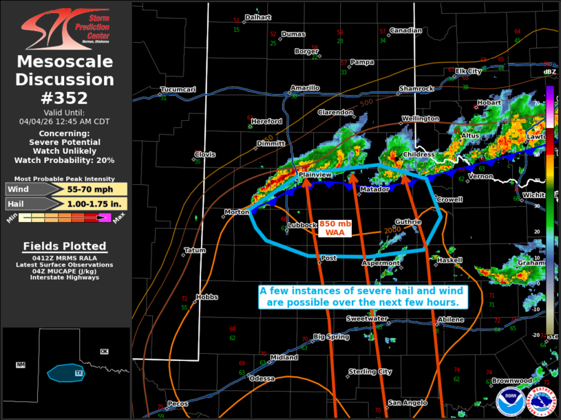
   Mesoscale Discussion 0352
   NWS Storm Prediction Center Norman OK
   1114 PM CDT Fri Apr 03 2026

   Areas affected...portions of northwestern Texas

   Concerning...Severe potential...Watch unlikely

   Valid 040414Z - 040545Z

   Probability of Watch Issuance...20 percent

   SUMMARY...A couple instances of severe hail and wind are possible
   over the next few hours.

   DISCUSSION...Convection has recently intensified over the TX South
   Plains, as warm and moist air around 850 mb continues to advect over
   a surface cold front. The 00Z MAF observed sounding showed 3000 J/kg
   MUCAPE over the warm sector given steep lapse rates aloft. With
   low-level WAA supporting convective initiation amid the
   aforementioned mid-level lapse rate environment, it is plausible
   that these elevated storms may be strong enough to produce isolated
   instances of severe hail. A severe gust may also be possible if any
   of the storms can catch up to the cold front. The severe threat
   should remain isolated though, so WW issuance is not currently
   anticipated.

   ..Squitieri/Smith.. 04/04/2026

   ...Please see www.spc.noaa.gov for graphic product...

   ATTN...WFO...OUN...SJT...LUB...

   LAT...LON   33810240 34250164 34360054 34199984 33739965 33349989
               33260068 33270153 33440214 33590228 33810240

   MOST PROBABLE PEAK WIND GUST...55-70 MPH
   MOST PROBABLE PEAK HAIL SIZE...1.00-1.75 IN
|
|
|
Top/All Mesoscale Discussions/Forecast Products/Home |
|
Source link