| Mesoscale Discussion 351 | |
| < Previous MD | |

|
|
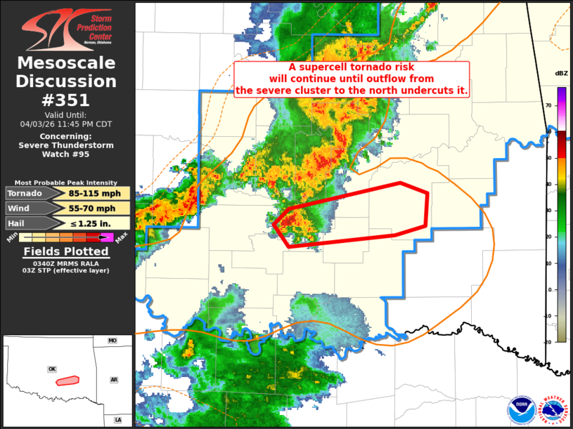
Mesoscale Discussion 0351 NWS Storm Prediction Center Norman OK 1041 PM CDT Fri Apr 03 2026 Areas affected...south-central into southeast OK Concerning...Severe Thunderstorm Watch 95... Valid 040341Z - 040445Z The severe weather threat for Severe Thunderstorm Watch 95 continues. SUMMARY...A supercell tornado risk has seemingly evolved and will probably continue until outflow from the severe cluster to its north undercuts it. DISCUSSION...A recently developed supercell in Pontotoc County will likely continue unimpeded to the east-northeast within a moist, adequately unstable, and appreciably strongly sheared environment. Although convective inhibition will gradually increase as temperatures slowly cool, the established supercell may continue to ingest surface-based air until the cold pool from the larger cluster to its north, undercuts and effectively pinches off warm/unstable inflow. In the meantime, a tornado will be possible along with damaging gusts and possibly marginally severe hail. ..Smith.. 04/04/2026 ...Please see www.spc.noaa.gov for graphic product... ATTN...WFO...TSA...OUN... LAT...LON 34709697 34839683 35039579 34959554 34699557 34629584 34549683 34709697 MOST PROBABLE PEAK TORNADO INTENSITY...85-115 MPH MOST PROBABLE PEAK WIND GUST...55-70 MPH MOST PROBABLE PEAK HAIL SIZE...UP TO 1.25 IN |
|
|
Top/All Mesoscale Discussions/Forecast Products/Home |
|
Source link