| Mesoscale Discussion 349 | |
| < Previous MD | |

|
|
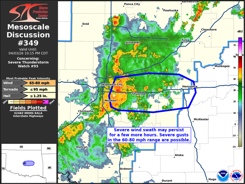
Mesoscale Discussion 0349 NWS Storm Prediction Center Norman OK 0951 PM CDT Fri Apr 03 2026 Areas affected...portions of central Oklahoma Concerning...Severe Thunderstorm Watch 93... Valid 040251Z - 040315Z The severe weather threat for Severe Thunderstorm Watch 93 continues. SUMMARY...A severe wind swath is expected to persist for at least the next 1-2 hours. Severe gusts may reach 60-80 mph in spots. DISCUSSION...A cluster of merging HP supercells have supported the development of a likely ongoing severe wind swath, with KTLX velocities exceeding 65 kts just a few hundred feet above the ground. Given an unstable boundary layer, some downward momentum transport of the stronger winds will likely continue over the next 1-2 hours, with 60-80 mph gusts likely given limited cooling of the boundary layer. A mesovortex over northern Pottawatomie County will likely focus more intense gusts and/or a brief tornado. ..Squitieri.. 04/04/2026 ...Please see www.spc.noaa.gov for graphic product... ATTN...WFO...TSA...OUN... LAT...LON 35619724 35679662 35659604 35559578 35389574 35149588 35089654 35119720 35159733 35339736 35619724 MOST PROBABLE PEAK TORNADO INTENSITY...UP TO 95 MPH MOST PROBABLE PEAK WIND GUST...65-80 MPH MOST PROBABLE PEAK HAIL SIZE...UP TO 1.25 IN |
|
|
Top/All Mesoscale Discussions/Forecast Products/Home |
|
Source link