| Mesoscale Discussion 343 | |
| < Previous MD | |
|
|
Mesoscale Discussion 0343
NWS Storm Prediction Center Norman OK
0315 PM CDT Fri Apr 03 2026
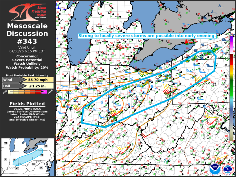
Areas affected...Parts of southeast IN/far northern KY into
OH...western/central PA...northern WV Panhandle...southwest NY
Concerning...Severe potential...Watch unlikely
Valid 032015Z - 032215Z
Probability of Watch Issuance...20 percent
SUMMARY...Strong to locally severe storms are possible into early
evening.
DISCUSSION...Showers and a few thunderstorms have recently developed
within a broad pre-frontal corridor from parts of IN/OH into
northwest PA/southwest NY. Within this corridor, MLCAPE increases
from around 500 J/kg across western PA/southwest NY, to the
1000-1500 J/kg range farther southwest into IN and western OH, where
stronger heating has occurred. Effective shear of 25-35 kt will be
sufficient for some storm organization, though with only modest
frontal convergence and large-scale ascent, coverage of robust
updrafts may tend to remain isolated.
Steepened low-level lapse rates and moderate southwesterly flow in
the 1-3 km AGL layer will support potential for locally
gusty/damaging winds with the strongest storms. If any organized
multicells or a marginal supercell can evolve with time, then some
threat for isolated hail could also develop.
..Dean/Hart.. 04/03/2026
...Please see www.spc.noaa.gov for graphic product...
ATTN...WFO...BGM...BUF...CTP...PBZ...RLX...CLE...ILN...LMK...
IWX...IND...
LAT...LON 38498499 38688655 39438648 40438468 41418099 41827994
42417858 42457778 42147742 41377759 40877863 40078042
39188316 38498499
MOST PROBABLE PEAK WIND GUST...55-70 MPH
MOST PROBABLE PEAK HAIL SIZE...UP TO 1.25 IN
|
|
|
Top/All Mesoscale Discussions/Forecast Products/Home |
|
Source link