| Mesoscale Discussion 339 | |
| < Previous MD Next MD > | |

|
|
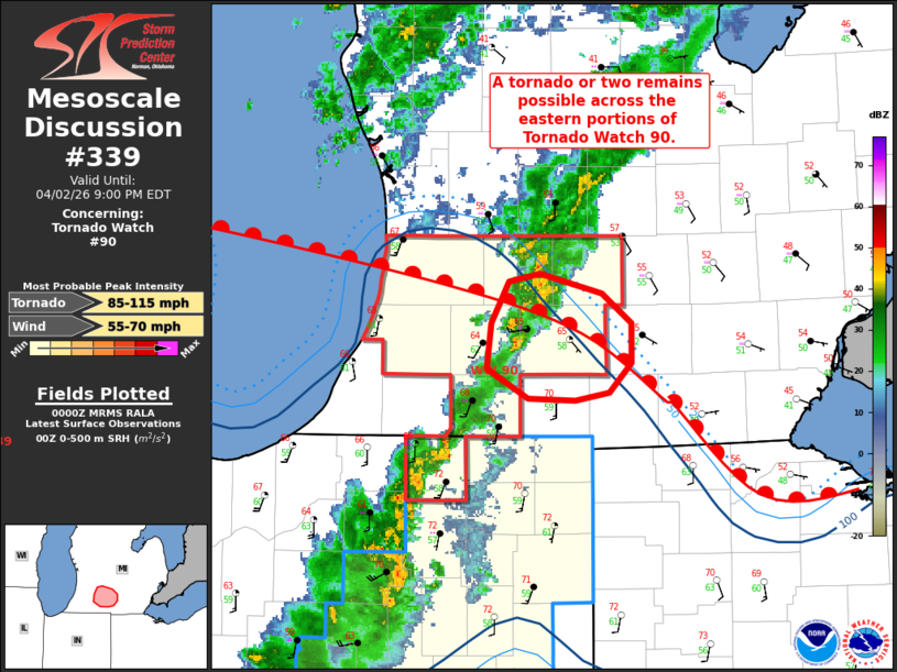
Mesoscale Discussion 0339 NWS Storm Prediction Center Norman OK 0703 PM CDT Thu Apr 02 2026 Areas affected...south-central Lower Michigan Concerning...Tornado Watch 90... Valid 030003Z - 030100Z The severe weather threat for Tornado Watch 90 continues. SUMMARY...The threat for an isolated tornado or two continues across the eastern portions of Tornado Watch 90. DISCUSSION...A series of supercells have been observed across portions of southwestern/south-central Lower Michigan over the last 1-2 hours. While these storms have quickly moved north in the vicinity of a surface warm front due to deep-layer flow orientation, periods of enhanced rotation have been noted with these cells in close proximity to the surface boundary. Latest mesoanalysis depicts weak buoyancy (250-500 J/kg MLCAPE) along and south of this boundary. Despite this weak instability, clockwise-curved low-level hodographs and 200-300 m2/s2 0-500 m SRH (per the IWX VWP) will continue to support supercell structures capable of an isolated tornado or two for another hour or so, especially in close proximity to the surface warm front. With time, increasing low-level stability owing to nocturnal cooling should act to reduce the severe threat. ..Chalmers.. 04/03/2026 ...Please see www.spc.noaa.gov for graphic product... ATTN...WFO...IWX...GRR... LAT...LON 42538536 42588515 42478474 42338454 42128453 41978468 41938491 41958523 42108551 42328548 42538536 MOST PROBABLE PEAK TORNADO INTENSITY...85-115 MPH MOST PROBABLE PEAK WIND GUST...55-70 MPH |
|
|
Top/All Mesoscale Discussions/Forecast Products/Home |
|
Source link