| Mesoscale Discussion 337 | |
| < Previous MD | |

|
|
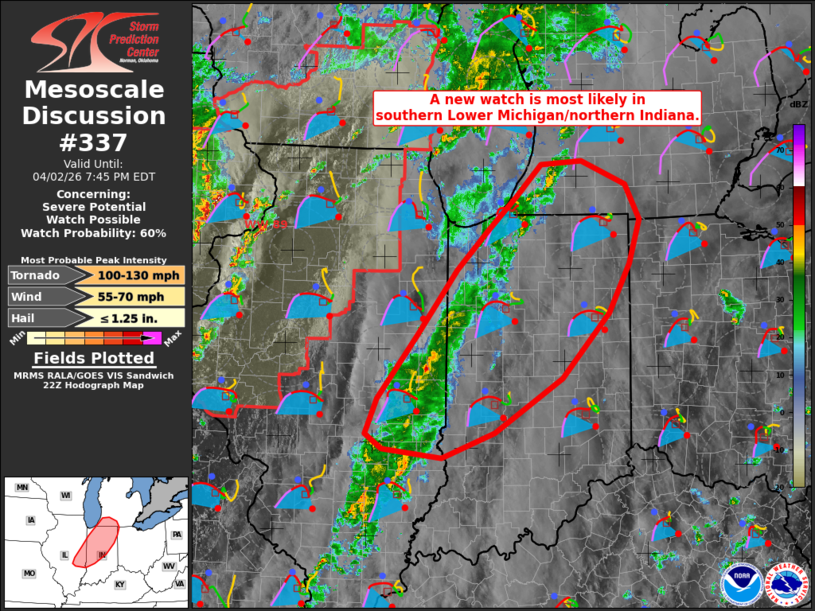
   Mesoscale Discussion 0337
   NWS Storm Prediction Center Norman OK
   0511 PM CDT Thu Apr 02 2026

   Areas affected...portions of east-central Illinois into
   central/northern Indiana and southern Lower Michigan

   Concerning...Severe potential...Watch possible

   Valid 022211Z - 022345Z

   Probability of Watch Issuance...60 percent

   SUMMARY...A broken band of thunderstorms currently located across
   portions of east-central Illinois into southwestern Michigan will
   likely persist into early evening, with some potential for
   intensification. Watch issuance may be needed within the next hour,
   especially for southern Lower Michigan and northern Indiana.

   DISCUSSION...Some recent intensification has been evident with a
   broken band of thunderstorms stretching from east-central Illinois
   into southwestern Michigan, with a couple of areas of strengthening
   embedded rotation noted. Ahead of this line, temperatures have
   warmed to the mid-70s across portions of central/northern Indiana
   and southern Lower Michigan amid filtered diurnal heating. Coupled
   with dewpoints around 60 F, this is supporting weak buoyancy of
   250-500 J/kg despite meager lapse rates aloft (5.5-6.0 C/km per
   latest mesoanalysis). While instability is forecast to remain modest
   at best, favorable kinematics, including 150-250 m2/s2 0-1 km SRH
   amid strong low-level flow (40-50+ kts at 1 km AGL per regional
   VWPs), may support some potential for damaging wind gusts and
   perhaps a tornado or two with any stronger cores that can become
   better established.

   ..Chalmers/Smith.. 04/02/2026

   ...Please see www.spc.noaa.gov for graphic product...

   ATTN...WFO...IWX...GRR...IND...LOT...ILX...

   LAT...LON   39268871 39668854 40388797 41138737 41568692 41968650
               42328611 42368551 42108484 41708463 41198480 40648511
               39908580 39288680 38988758 39088847 39268871

   MOST PROBABLE PEAK TORNADO INTENSITY...100-130 MPH
   MOST PROBABLE PEAK WIND GUST...55-70 MPH
   MOST PROBABLE PEAK HAIL SIZE...UP TO 1.25 IN
|
|
|
Top/All Mesoscale Discussions/Forecast Products/Home |
|
Source link