| Mesoscale Discussion 335 | |
| < Previous MD | |
|
|
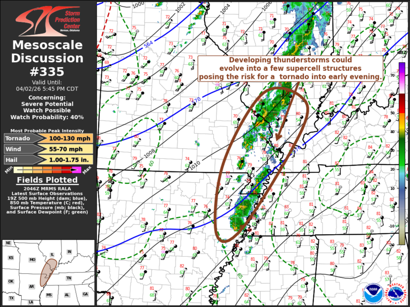
   Mesoscale Discussion 0335
   NWS Storm Prediction Center Norman OK
   0348 PM CDT Thu Apr 02 2026

   Areas affected...parts of northeastern Arkansas....southeastern
   Missouri...adjacent portions of western Kentucky and
   Tennessee...southern Illinois

   Concerning...Severe potential...Watch possible

   Valid 022048Z - 022245Z

   Probability of Watch Issuance...40 percent

   SUMMARY...Scattered thunderstorm development is underway and
   probably will persist into early evening, with potential for
   intensification which could be accompanied by at least the risk for
   a tornado or two.  It is not yet certain that a severe weather watch
   will be needed, but trends will continue to be monitored for this
   possibility.

   DISCUSSION...Thunderstorm development has recently been initiating
   in a broken band north of Poplar Bluff MO toward the Carbondale IL
   vicinity.  This appears to be occurring along a corridor of better
   low-level moisture return and weak developing surface pressure fall
   axis, near the southern periphery of the mid-level cold pool
   associated with negatively tilted short wave troughing progressing
   across and northeast of the lower Missouri Valley.

   Destabilization has been sufficient to support only weak mixed-layer
   CAPE.  This may not improve much through the remainder of the
   afternoon, except perhaps across parts of northeastern Arkansas into
   the Missouri Bootheel vicinity, based on latest Rapid Refresh
   guidance.  Even so, this appears focused along the southeastern
   periphery of a strong southerly low-level jet axis, including 40-50
   kt speeds around 850 mb.  It appears possible that low-level
   hodographs and thermodynamic profiles could become supportive of
   supercell structures capable of producing tornadoes.  However, the
   extent of this potential remains unclear.

   ..Kerr/Hart.. 04/02/2026

   ...Please see www.spc.noaa.gov for graphic product...

   ATTN...WFO...PAH...MEG...LSX...LZK...

   LAT...LON   38328857 37558852 35189028 35039105 36719087 38388970
               38328857

   MOST PROBABLE PEAK TORNADO INTENSITY...100-130 MPH
   MOST PROBABLE PEAK WIND GUST...55-70 MPH
   MOST PROBABLE PEAK HAIL SIZE...1.00-1.75 IN
|
|
|
Top/All Mesoscale Discussions/Forecast Products/Home |
|
Source link