| Mesoscale Discussion 333 | |
| < Previous MD | |

|
|
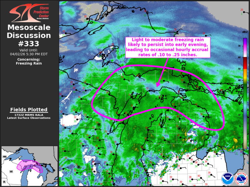
   Mesoscale Discussion 0333
   NWS Storm Prediction Center Norman OK
   1234 PM CDT Thu Apr 02 2026

   Areas affected...much of central and eastern Upper
   Michigan...adjacent northeastern Wisconsin and portions of northern
   Lower Michigan

   Concerning...Freezing rain

   Valid 021734Z - 022130Z

   SUMMARY...Light to moderate freezing rain is likely to continue to
   develop and overspread the region through 5-7 PM EDT, with primary
   accrual on elevated surfaces and vegetation.

   DISCUSSION...As a still sub-1000 mb surface cyclone continues to
   migrate east-northeastward into and through portions of
   southern/eastern Iowa this afternoon, a fairly sharp warm frontal
   zone to its east-northeast is forecast to continue to surge
   northward across Wisconsin and Michigan.  This is likely to occur
   near the nose of a 40-50 kt southerly 850 mb jet, with strong
   lower/mid-tropospheric warm advection and frontogenetic forcing
   maintaining light and developing embedded bands of moderate
   precipitation.

   While surface temperatures near or just below 30F are likely to also
   be maintained at least into late afternoon or early evening, model
   forecast soundings indicate notable warming above freezing in a
   deepening layer above the surface, northward through much of central
   and eastern Upper Michigan by 21-23Z.  As this occurs, precipitation
   rates may support at least occasional hourly freezing rain accrual
   in excess of .10 inches, perhaps up to .25 inches.

   ..Kerr.. 04/02/2026

   ...Please see www.spc.noaa.gov for graphic product...

   ATTN...WFO...APX...MQT...GRB...

   LAT...LON   45178681 44948770 45388892 46308828 46828705 46538410
               45548285 44678265 44718363 45378519 45178681
|
|
|
Top/All Mesoscale Discussions/Forecast Products/Home |
|
Source link