|
|
| Mesoscale Discussion 331 | |
| < Previous MD Next MD > | |

|
|
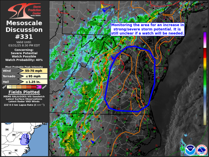
   Mesoscale Discussion 0331
   NWS Storm Prediction Center Norman OK
   0531 PM CDT Mon Mar 31 2025

   Areas affected...Portions of eastern Virginia and southern Maryland

   Concerning...Severe potential...Watch possible

   Valid 312231Z - 010030Z

   Probability of Watch Issuance...40 percent

   SUMMARY...Monitoring portions of eastern Virginia and southern
   Maryland for an increase in strong/severe storm potential. The
   primary concern would be damaging wind gusts. It is still unclear if
   a watch is needed, though trends are being monitored.

   DISCUSSION...A band of showers with embedded thunderstorms is
   advancing east-northeastward across central Virginia -- ahead of a
   broad midlevel trough and related surface front. Ahead of these
   storms, earlier diurnal heating has resulted in upper 70s/lower 80s
   surface temperatures and steep boundary-layer lapse rates (see 18Z
   IAD sounding) amid upper 50s/lower 60s dewpoints. Despite this
   low-level destabilization, weak midlevel lapse rates are still
   limiting buoyancy (MLCAPE around 500 J/kg). Around 40 kt of
   west-southwesterly deep-layer shear oriented perpendicular to the
   band of showers and storms could result in some convective
   organization with eastward extent, and the steep low-level lapse
   rates may promote damaging wind gusts -- depending on how organized
   the cold pool can become. Given the weak buoyancy, it is still
   unclear if a watch is needed, though convective trends are being
   monitored.

   ..Weinman/Mosier.. 03/31/2025

   ...Please see www.spc.noaa.gov for graphic product...

   ATTN...WFO...PHI...AKQ...LWX...

   LAT...LON   36807803 37167825 38377799 38917767 39237716 39277677
               39087599 38727572 37807575 36917608 36657657 36707762
               36807803

   MOST PROBABLE PEAK TORNADO INTENSITY...UP TO 95 MPH
   MOST PROBABLE PEAK WIND GUST...55-70 MPH
   MOST PROBABLE PEAK HAIL SIZE...UP TO 1.25 IN
|
|
|
Top/All Mesoscale Discussions/Forecast Products/Home |
|
Source link