| Mesoscale Discussion 330 | |
| < Previous MD | |
|
|
Mesoscale Discussion 0330
NWS Storm Prediction Center Norman OK
0355 AM CDT Thu Apr 02 2026
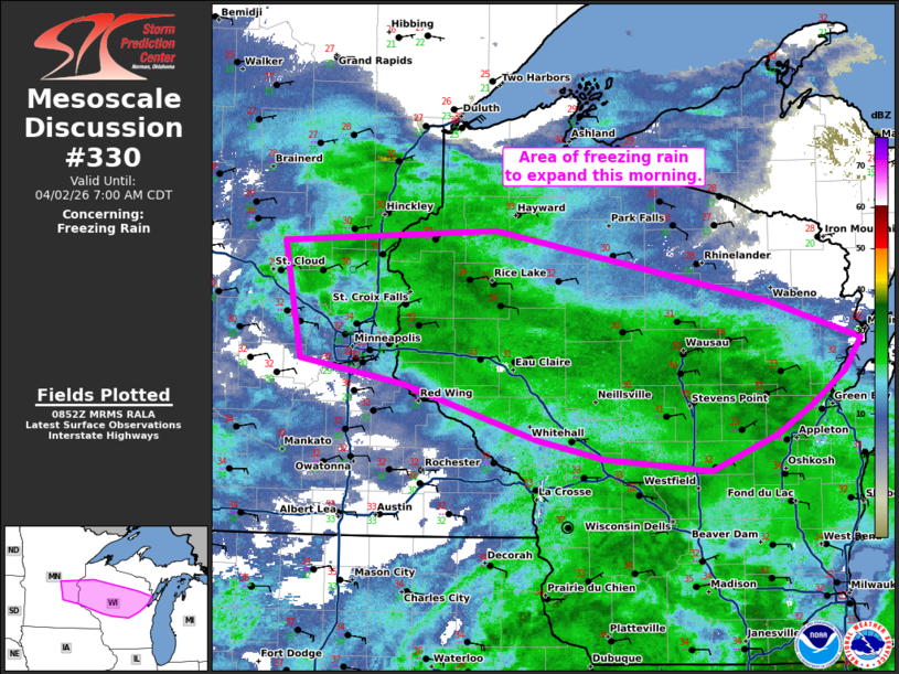
Areas affected...east-central Minnesota across central Wisconsin.
Concerning...Freezing rain
Valid 020855Z - 021200Z
SUMMARY...An area of freezing rain will expand this morning from
eastern Minnesota to central Wisconsin.
DISCUSSION...Several observation sites are recording moderate ice
accretion this morning from eastern Minnesota to central Wisconsin.
A strengthening pressure gradient between the strong high pressure
across Quebec and the developing cyclone across the Plains will
maintain moderate easterly flow early this morning and keep
temperatures below freezing. Forecast soundings show the warm nose
near the Lake Superior shore. Therefore, as precipitation continues
to expand northward, expect most of the precipitation to remain
freezing rain, with some sleet more likely with northward extent.
..Bentley.. 04/02/2026
...Please see www.spc.noaa.gov for graphic product...
ATTN...WFO...GRB...DLH...ARX...MPX...
LAT...LON 45028768 44778785 44528821 44298860 44018932 44109050
44259123 44699270 44889383 45799401 45899169 45328869
45028768
|
|
|
Top/All Mesoscale Discussions/Forecast Products/Home |
|
Source link