| Mesoscale Discussion 33 | |
| < Previous MD | |

|
|
Mesoscale Discussion 0033
NWS Storm Prediction Center Norman OK
0517 PM CST Thu Jan 22 2026
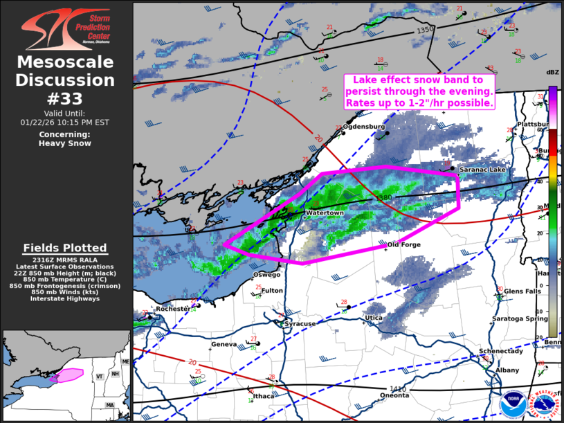
Areas affected...portions of Upstate New York
Concerning...Heavy snow
Valid 222317Z - 230315Z
SUMMARY...Heavy lake effect snow band to persist with potential for
rates 1-2"/hr through the evening.
DISCUSSION...A band of lake effect snow continues along and east of
Lake Ontario across portions of the Tug Hill Plateau. Heavy snow has
been reported within this band periodically through the afternoon in
Watertown and Fort Drum, with visibility <1/4 mi at times. This band
has also produced occasional lightning. Westerly surface flow is
providing optimal long fetch axis across Lake Ontario amid steep
lapse rates (7-8 C/km at 0-3 km). In addition, a mid-level trough
across Canada is shifting southward, with very cool air aloft and
forcing for ascent overspreading the region. Hi-res guidance
suggests that rates will increase through the evening, with
potential for 1-2"/hr rates. This band will likely persist through
the overnight, with some north/south shift possible.
..Thornton.. 01/22/2026
...Please see www.spc.noaa.gov for graphic product...
ATTN...WFO...BTV...ALY...BUF...
LAT...LON 43747683 44177596 44337571 44407497 44327414 44047412
43767484 43587593 43667654 43747683
|
|
|
Top/All Mesoscale Discussions/Forecast Products/Home |
|
Source link