| Mesoscale Discussion 329 | |
| < Previous MD | |
|
|
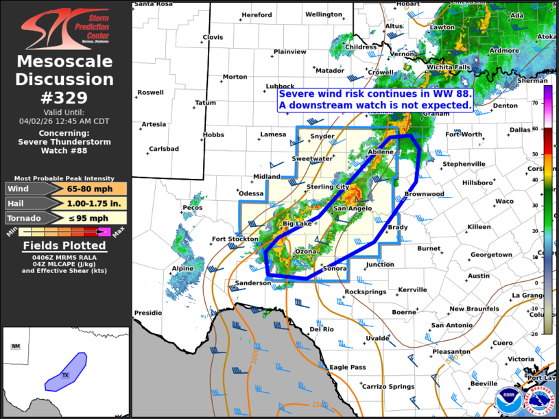
Mesoscale Discussion 0329 NWS Storm Prediction Center Norman OK 1108 PM CDT Wed Apr 01 2026 Areas affected...Parts of southwest Texas Concerning...Severe Thunderstorm Watch 88... Valid 020408Z - 020545Z The severe weather threat for Severe Thunderstorm Watch 88 continues. SUMMARY...The severe wind risk continues in Severe Thunderstorm Watch #88. A downstream watch is not currently expected, though trends are being monitored. DISCUSSION...A small bowing thunderstorm complex has evolved northeast of San Angelo, along the northeastern edge of remaining surface-based buoyancy. Around 40 kt of 0-6 km shear (per SJT VWP) oriented perpendicular to the gust front of this activity should maintain its current intensity for the next hour or so in Severe Thunderstorm Watch #88 -- with an associated risk of severe wind gusts. However, these storms will gradually move eastward into an area of weaker buoyancy and increasing low-level inhibition. Current thinking is that this will result in a gradual weakening trend. Therefore, a downstream watch is not currently expected, though convective trends are being monitored. ..Weinman.. 04/02/2026 ...Please see www.spc.noaa.gov for graphic product... ATTN...WFO...FWD...SJT...MAF... LAT...LON 30770176 31030150 31400069 32529953 32779924 32819881 32579863 32009872 30969958 30310094 30370171 30770176 MOST PROBABLE PEAK TORNADO INTENSITY...UP TO 95 MPH MOST PROBABLE PEAK WIND GUST...65-80 MPH MOST PROBABLE PEAK HAIL SIZE...1.00-1.75 IN |
|
|
Top/All Mesoscale Discussions/Forecast Products/Home |
|
Source link