| Mesoscale Discussion 325 | |
| < Previous MD | |
|
|
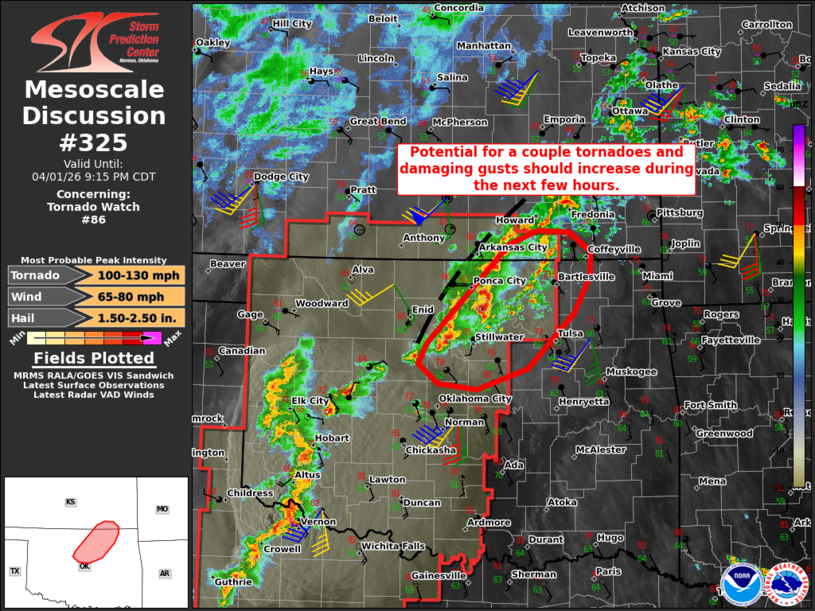
Mesoscale Discussion 0325 NWS Storm Prediction Center Norman OK 0709 PM CDT Wed Apr 01 2026 Areas affected...North-central Oklahoma into far southeastern KS Concerning...Tornado Watch 86... Valid 020009Z - 020215Z The severe weather threat for Tornado Watch 86 continues. SUMMARY...Severe risk should increase over the next few hours, with the primary concerns being a couple tornadoes and damaging wind gusts. DISCUSSION...Clusters of thunderstorms evolving along/south of the surface boundary in north-central OK are showing some signs of contraction into more intense cells with supercellular characteristics during the last 30 minute or so. These storms should maintain residence time within the warm/moist warm sector (middle 60s dewpoints) south of the boundary over the next few hours, given west-southwesterly deep-layer shear vectors/storm motions. Around 40 to 50 kt of effective shear and increasing low-level hodograph size/curvature (upwards of 200 m2/s2 effective SRH) with the strengthening low-level jet should promote supercell clusters -- capable of producing a couple tornadoes and damaging wind gusts during the next few hours. ..Weinman.. 04/02/2026 ...Please see www.spc.noaa.gov for graphic product... ATTN...WFO...TSA...ICT...OUN... LAT...LON 36439577 35869637 35639702 35699753 35909779 36119767 37169662 37309623 37289581 37079555 36839556 36439577 MOST PROBABLE PEAK TORNADO INTENSITY...100-130 MPH MOST PROBABLE PEAK WIND GUST...65-80 MPH MOST PROBABLE PEAK HAIL SIZE...1.50-2.50 IN |
|
|
Top/All Mesoscale Discussions/Forecast Products/Home |
|
Source link