| Mesoscale Discussion 324 | |
| < Previous MD | |

|
|
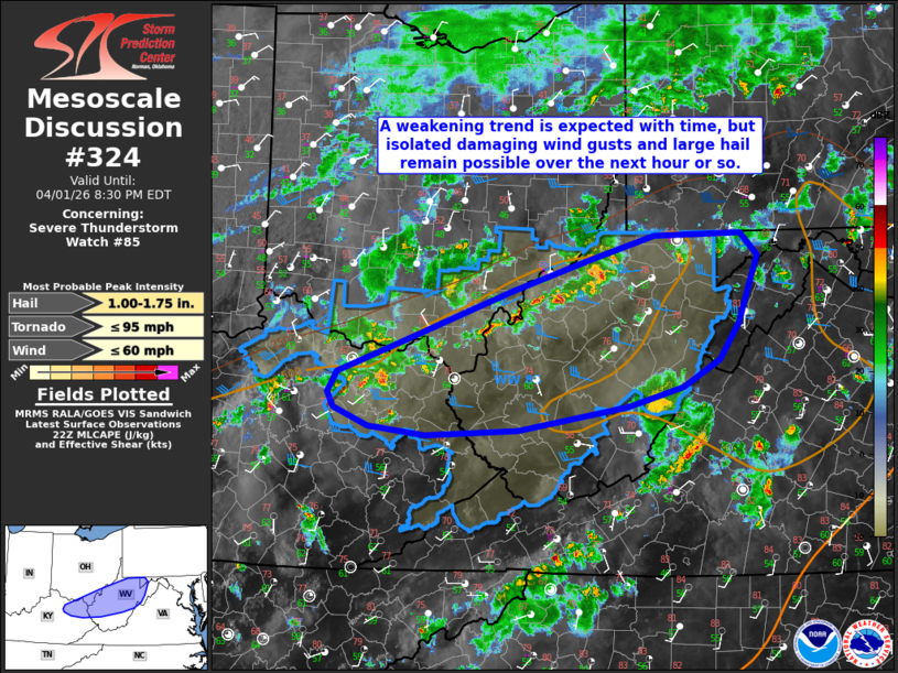
Mesoscale Discussion 0324 NWS Storm Prediction Center Norman OK 0557 PM CDT Wed Apr 01 2026 Areas affected...middle/upper Ohio Valley Concerning...Severe Thunderstorm Watch 85... Valid 012257Z - 020030Z The severe weather threat for Severe Thunderstorm Watch 85 continues. SUMMARY...A gradual weakening trend is anticipated this evening across WW0085, but at least some risk for strong to occasionally damaging wind gusts and isolated severe hail is expected for another hour or so. DISCUSSION...Ongoing convective activity within WW85 is noted along/near the Ohio River. Expectation is for this activity to gradually weaken with time this evening as nocturnal boundary layer stabilization increases low-level inhibition. However, 500-1000 J/kg MLCAPE and around 30 kts of effective bulk shear (per latest mesoanalysis) should continue to support at least some threat for strong to occasionally damaging winds and isolated large hail over the next hour or so. The greatest short term risk appears to be associated with a stronger storm cluster currently located across northwestern West Virginia. A new watch is not anticipated at this time; however, a local extension may be needed should a stronger storm or two persist past the scheduled expiration of WW85 at 00Z. ..Chalmers.. 04/01/2026 ...Please see www.spc.noaa.gov for graphic product... ATTN...WFO...LWX...RNK...PBZ...RLX...JKL...ILN...LMK... LAT...LON 37888179 37838289 37928356 38098396 38228404 38418392 38698318 39188187 39478091 39688019 39707917 39507897 38877920 38537943 38297986 38108050 37888179 MOST PROBABLE PEAK TORNADO INTENSITY...UP TO 95 MPH MOST PROBABLE PEAK WIND GUST...UP TO 60 MPH MOST PROBABLE PEAK HAIL SIZE...1.00-1.75 IN |
|
|
Top/All Mesoscale Discussions/Forecast Products/Home |
|
Source link