| Mesoscale Discussion 323 | |
| < Previous MD Next MD > | |

|
|
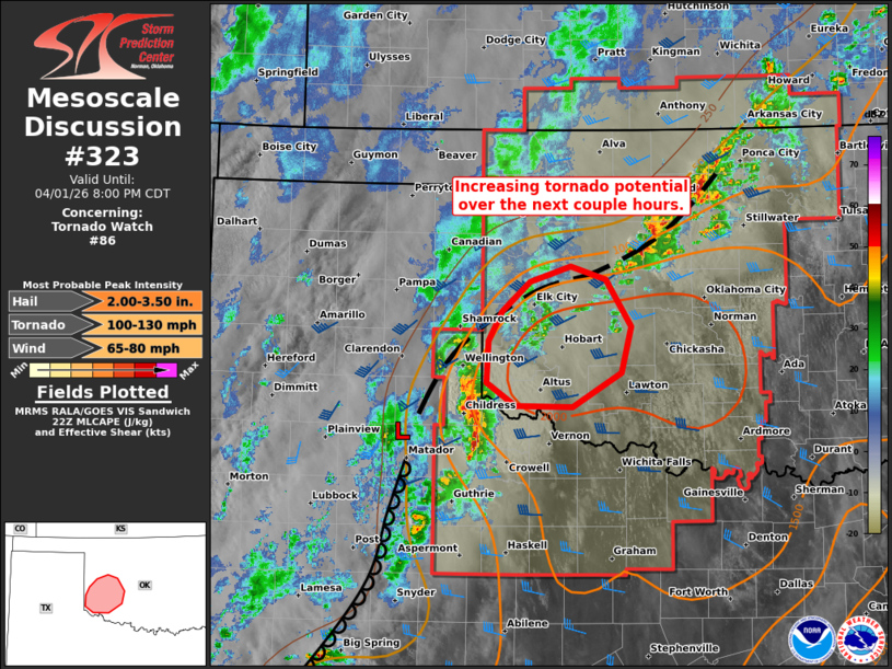
Mesoscale Discussion 0323 NWS Storm Prediction Center Norman OK 0555 PM CDT Wed Apr 01 2026 Areas affected...Southwestern Oklahoma Concerning...Tornado Watch 86... Valid 012255Z - 020100Z The severe weather threat for Tornado Watch 86 continues. SUMMARY...The tornado risk will increase over the next couple hours in southwestern Oklahoma -- within Tornado Watch #86. DISCUSSION...A cluster of thunderstorms is evolving/strengthening near the triple point around Childress TX -- where several severe gusts have recently been measured. Over the next couple hours, these storms, and additional developing storms along its northern/eastern flank, should continue to intensify as they move into a warm/moist boundary layer and steep deep-layer lapse rates (around 2000 J/kg MLCAPE). Clockwise-curved hodographs will increase in size (250+ m2/s2 effective SRH) as the nocturnal low-level jet strengthens over the next couple hours, favoring intensifying low-level mesocyclones/right-movers. As a result, the tornado risk (some strong) will increase into southwestern OK over the next couple hours, along with the potential for very large hail and severe wind gusts. ..Weinman.. 04/01/2026 ...Please see www.spc.noaa.gov for graphic product... ATTN...WFO...OUN... LAT...LON 34499963 34709994 35079993 35359978 35629946 35759902 35639862 35209835 34799846 34489899 34499963 MOST PROBABLE PEAK TORNADO INTENSITY...100-130 MPH MOST PROBABLE PEAK WIND GUST...65-80 MPH MOST PROBABLE PEAK HAIL SIZE...2.00-3.50 IN |
|
|
Top/All Mesoscale Discussions/Forecast Products/Home |
|
Source link