| Mesoscale Discussion 318 | |
| < Previous MD | |

|
|
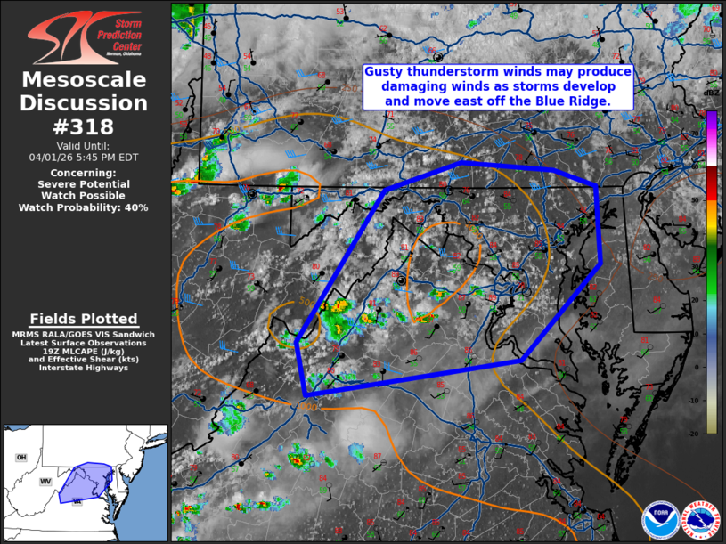
   Mesoscale Discussion 0318
   NWS Storm Prediction Center Norman OK
   0250 PM CDT Wed Apr 01 2026

   Areas affected...Northern Virginia...central/eastern Maryland...far
   southern Pennsylvania

   Concerning...Severe potential...Watch possible

   Valid 011950Z - 012145Z

   Probability of Watch Issuance...40 percent

   SUMMARY...Isolated to widely scattered storms may develop and move
   east off of the Blue Ridge. Isolated wind damage may occur with the
   strongest storms. Limited coverage of stronger activity limits
   confidence in the need for a watch this afternoon. Trends will be
   monitored.

   DISCUSSION...The morning sounding from Dulles showed a rather modest
   moist layer. Accordingly, dewpoints have had a tendency to mix into
   the low/mid 50s F this afternoon. With ample surface heating,
   however, 750-1000 J/kg MLCAPE has developed. Convection has
   increased within the Blue Ridge and has shown some deepening
   recently. Isolated to widely scattered thunderstorms may eventually
   evolve out of this activity. Deep-layer shear is only around 30 kts.
   Convection that is able to mature will likely only be marginally
   organized. The primary hazard with storms this afternoon will be
   damaging winds gusts on account of the modestly dry/well-mixed
   boundary layer.

   ..Wendt/Hart.. 04/01/2026

   ...Please see www.spc.noaa.gov for graphic product...

   ATTN...WFO...PHI...AKQ...CTP...LWX...RNK...

   LAT...LON   37927928 38377939 39697843 39937759 39867655 39737608
               39067604 38227693 38127772 37927928
|
|
|
Top/All Mesoscale Discussions/Forecast Products/Home |
|
Source link