| Mesoscale Discussion 311 | |
| < Previous MD | |
|
|
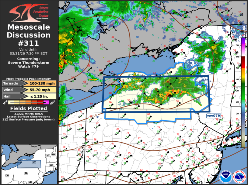
Mesoscale Discussion 0311 NWS Storm Prediction Center Norman OK 0435 PM CDT Tue Mar 31 2026 Areas affected...New York - Northern Pennsylvania Concerning...Severe Thunderstorm Watch 79... Valid 312135Z - 312330Z The severe weather threat for Severe Thunderstorm Watch 79 continues. SUMMARY...Scattered strong/severe thunderstorms will spread east across ww079 this evening. Large hail and damaging winds remain the primary concern. DISCUSSION...Several thunderstorm clusters, including a few supercells, have developed well ahead of the primary low-amplitude short-wave trough currently advancing across the Ohio Valley. Most buoyant air mass is holding across the southwestern half of the watch where MUCAPE is approaching 1000 J/kg; however, instability is considerably weaker downstream across the Hudson Valley and this will likely contribute to gradual weakening along the leading edge as the convection begins to spread east of the watch over the next few hours. Until then, large hail and damaging winds may accompany the more robust updrafts, especially across the southern half of the watch. ..Darrow.. 03/31/2026 ...Please see www.spc.noaa.gov for graphic product... ATTN...WFO...ALY...BGM...BUF...CTP...CLE... LAT...LON 43147971 43187455 41877453 41867974 43147971 MOST PROBABLE PEAK TORNADO INTENSITY...100-130 MPH MOST PROBABLE PEAK WIND GUST...55-70 MPH MOST PROBABLE PEAK HAIL SIZE...UP TO 1.25 IN |
|
|
Top/All Mesoscale Discussions/Forecast Products/Home |
|
Source link