| Mesoscale Discussion 31 | |
| < Previous MD | |
|
|
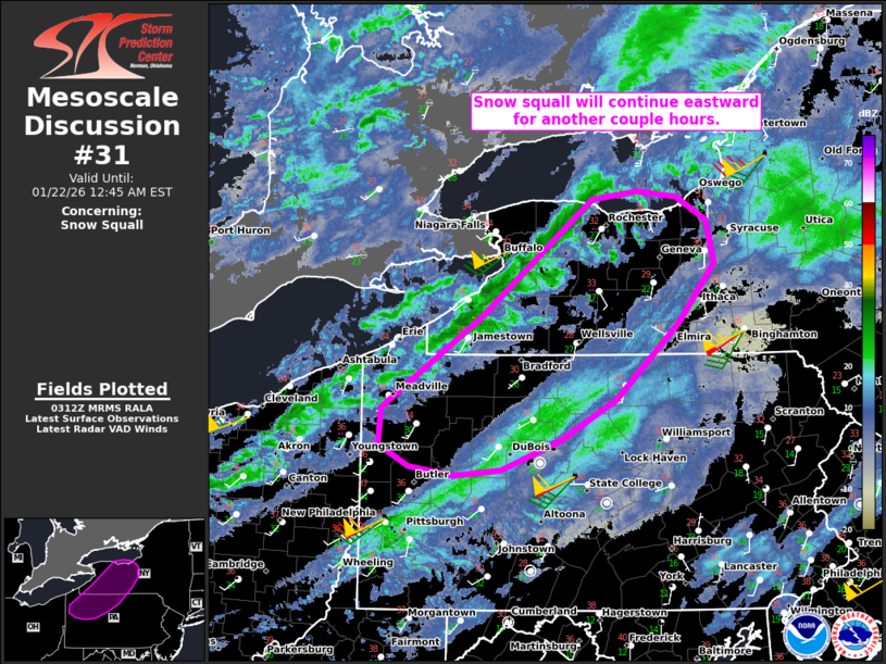
   Mesoscale Discussion 0031
   NWS Storm Prediction Center Norman OK
   0914 PM CST Wed Jan 21 2026

   Areas affected...Parts of southwestern NY and northwestern PA

   Concerning...Snow Squall

   Valid 220314Z - 220545Z

   SUMMARY...A snow squall will continue tracking eastward across parts
   of southwestern New York and northwestern Pennsylvania during the
   next few hours.

   DISCUSSION...A snow squall has recently organized/intensified as it
   moves eastward out of Ontario Canada. As the squall passed over
   KBUF, visibility dropped to 1/8 mile with a 28-kt gust. As ascent in
   the left-exit region of a robust midlevel jet streak continues
   overspreading western NY, the snow squall will continue tracking
   eastward along an associated surface winds shift during the next few
   hours. Around 40-45 kt of west-southwesterly flow in the lowest 1 km
   AGL (sampled by regional VWPs) and modestly steepened low-level
   lapse rates will continue to support strong gusts and visibility
   reductions of 1/4 mile or less in bursts of heavy snow.

   ..Weinman.. 01/22/2026

   ...Please see www.spc.noaa.gov for graphic product...

   ATTN...WFO...BGM...BUF...CTP...PBZ...CLE...

   LAT...LON   41528029 42327910 43377777 43447723 43407677 43187641
               42807632 42277675 41607749 41227817 40977886 40927942
               40997995 41198031 41528029
|
|
|
Top/All Mesoscale Discussions/Forecast Products/Home |
|
Source link