| Mesoscale Discussion 282 | |
| < Previous MD | |

|
|
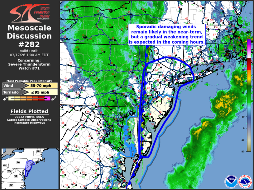
Mesoscale Discussion 0282 NWS Storm Prediction Center Norman OK 0955 PM CDT Mon Mar 16 2026 Areas affected...Portions of the Mid-Atlantic region Concerning...Severe Thunderstorm Watch 71... Valid 170255Z - 170500Z The severe weather threat for Severe Thunderstorm Watch 71 continues. SUMMARY...Damaging winds remain likely over the next hour across parts of the Mid-Atlantic, but a gradual weakening trend is expected as a squall line moves into a more stable air mass. DISCUSSION...Scattered reports of wind damage continue to filter in as a shallow squall line pushes east across the Mid-Atlantic region. Although most of this line will soon move offshore in the coming hour or so, the northern portion of the line will continue to move into NJ and perhaps far southern NY in the next few hours. Based on recent velocity data and surface observations, damaging winds will remain likely roughly over the next hour. With time, this band will move into a cooler/drier air mass where temperatures are only in the upper 50s (with pockets of low 60s). Based on the recent 00z OKX RAOB and recent forecast soundings, these temperatures (coupled with dewpoints in the low 50s) may be sufficiently cool to modulate downward momentum flux to the surface within the convective downdrafts. That said, the KOKX VWP continues to sample 70 knot winds within the lowest 0.5 km, so an isolated damaging wind threat may persist into southern NY as the line gradually weakens. Confidence in the persistence of the damaging wind threat beyond the next 1-2 hours is limited given the overall degradation of buoyancy with northeastward extent; downstream watch issuance is not expected. ..Moore.. 03/17/2026 ...Please see www.spc.noaa.gov for graphic product... ATTN...WFO...OKX...ALY...PHI...BGM...AKQ... LAT...LON 38007563 38877564 39687561 41087545 41337523 41557442 41537402 41387357 41197321 40847303 40667305 40587336 40467369 40267380 39977389 39657400 39147445 38717478 38347496 38017510 37867521 37877539 37897550 38007563 MOST PROBABLE PEAK TORNADO INTENSITY...UP TO 95 MPH MOST PROBABLE PEAK WIND GUST...55-70 MPH |
|
|
Top/All Mesoscale Discussions/Forecast Products/Home |
|
Source link