| Mesoscale Discussion 277 | |
| < Previous MD Next MD > | |

|
|
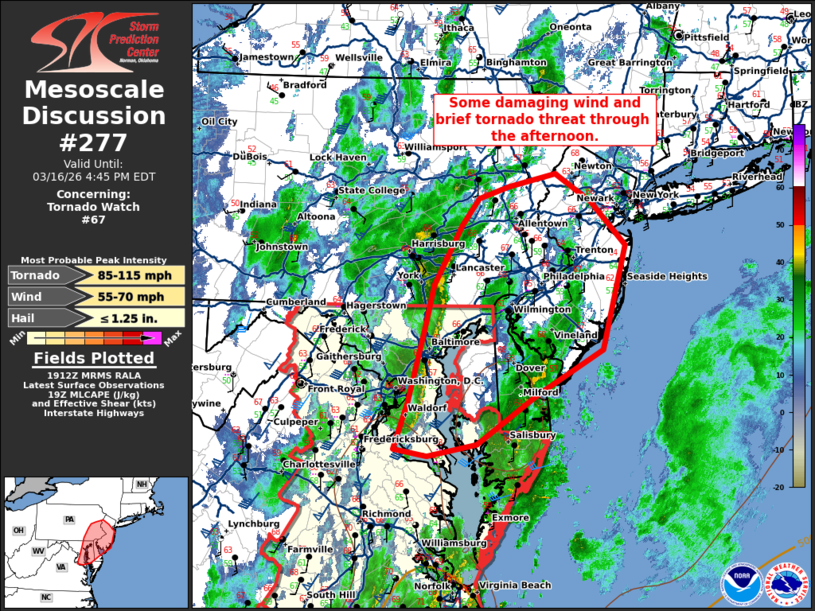
Mesoscale Discussion 0277 NWS Storm Prediction Center Norman OK 0214 PM CDT Mon Mar 16 2026 Areas affected...the DelMarVa into southeast Pennsylvania and New Jersey Concerning...Tornado Watch 67... Valid 161914Z - 162045Z The severe weather threat for Tornado Watch 67 continues. SUMMARY...Some damaging wind and brief tornado threat will persist through the afternoon. DISCUSSION...A line of convection (with minimal lightning) continues from northern Virginia to south-central Pennsylvania. This line has had sporadic damaging wind reports and perhaps a tornado or two this morning into the early afternoon. Weak instability ahead of this line may maintain some isolated damaging wind/isolated tornado threat through the afternoon. The tornado watch will be cancelled in the wake of this line of storms. Some threat for damaging convective winds with the front this evening still persists, but will be handled with an additional watch later this evening if necessary. ..Bentley.. 03/16/2026 ...Please see www.spc.noaa.gov for graphic product... ATTN...WFO...OKX...PHI...AKQ...CTP...LWX... LAT...LON 39127685 39597669 39947654 40527618 40807596 40917557 41047497 40767451 40327405 39287435 38837521 38337599 38217663 38247709 39127685 MOST PROBABLE PEAK TORNADO INTENSITY...85-115 MPH MOST PROBABLE PEAK WIND GUST...55-70 MPH MOST PROBABLE PEAK HAIL SIZE...UP TO 1.25 IN |
|
|
Top/All Mesoscale Discussions/Forecast Products/Home |
|
Source link